You are here: Home > Network List > US - United States National Seismic Network Stations List
> Station MNTX Cornudas Mountains, Texas, USA > Earthquake Result Viewer
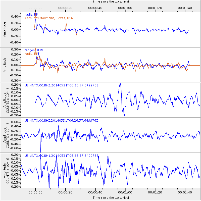
MNTX Cornudas Mountains, Texas, USA - Earthquake Result Viewer
*The percent match for this event was below the threshold and hence no stack was calculated.
| Earthquake location: |
Komandorskiye Ostrova Region |
| Earthquake latitude/longitude: |
55.0/165.7 |
| Earthquake time(UTC): |
2014/05/31 (151) 06:16:56 GMT |
| Earthquake Depth: |
20 km |
| Earthquake Magnitude: |
5.5 MW |
| Earthquake Catalog/Contributor: |
ISC/ISC |
|
| Network: |
US United States National Seismic Network |
| Station: |
MNTX Cornudas Mountains, Texas, USA |
| Lat/Lon: |
31.70 N/105.38 W |
| Elevation: |
404 m |
|
| Distance: |
64.1 deg |
| Az: |
71.312 deg |
| Baz: |
320.178 deg |
| Ray Param: |
$rayparam |
*The percent match for this event was below the threshold and hence was not used in the summary stack. |
|
| Radial Match: |
52.19632 % |
| Radial Bump: |
400 |
| Transverse Match: |
70.42599 % |
| Transverse Bump: |
400 |
| SOD ConfigId: |
3390531 |
| Insert Time: |
2019-04-12 02:54:13.403 +0000 |
| GWidth: |
2.5 |
| Max Bumps: |
400 |
| Tol: |
0.001 |
|
Signal To Noise
| Channel | StoN | STA | LTA |
| US:MNTX:00:BHZ:20140531T06:26:57.649976Z | 3.188587 | 2.3637361E-7 | 7.413115E-8 |
| US:MNTX:00:BH1:20140531T06:26:57.649976Z | 1.7137771 | 7.947676E-8 | 4.6375202E-8 |
| US:MNTX:00:BH2:20140531T06:26:57.649976Z | 0.58027726 | 2.61284E-8 | 4.502744E-8 |
| Arrivals |
| Ps | |
| PpPs | |
| PsPs/PpSs | |


