You are here: Home > Network List > UW - Pacific Northwest Regional Seismic Network Stations List
> Station MRBL Marblemount, WA, USA > Earthquake Result Viewer
MRBL Marblemount, WA, USA - Earthquake Result Viewer
| Earthquake location: |
Solomon Islands |
| Earthquake latitude/longitude: |
-9.7/159.7 |
| Earthquake time(UTC): |
2012/07/25 (207) 11:20:27 GMT |
| Earthquake Depth: |
20 km |
| Earthquake Magnitude: |
6.4 MB, 6.5 MS, 6.4 MW, 6.3 MW |
| Earthquake Catalog/Contributor: |
WHDF/NEIC |
|
| Network: |
UW Pacific Northwest Regional Seismic Network |
| Station: |
MRBL Marblemount, WA, USA |
| Lat/Lon: |
48.52 N/121.48 W |
| Elevation: |
75 m |
|
| Distance: |
89.9 deg |
| Az: |
40.707 deg |
| Baz: |
255.261 deg |
| Ray Param: |
0.041713193 |
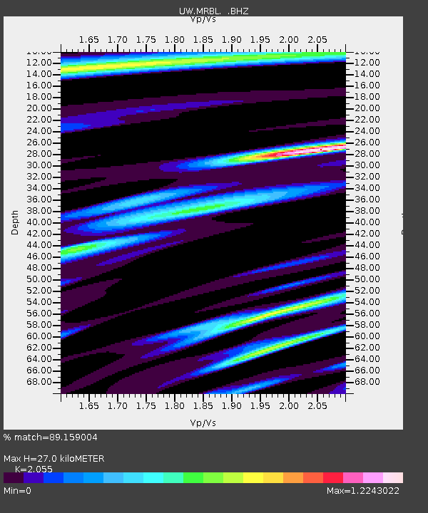
| Estimated Moho Depth: |
27.0 km |
| Estimated Crust Vp/Vs: |
2.06 |
| Assumed Crust Vp: |
6.566 km/s |
| Estimated Crust Vs: |
3.195 km/s |
| Estimated Crust Poisson's Ratio: |
0.34 |
|
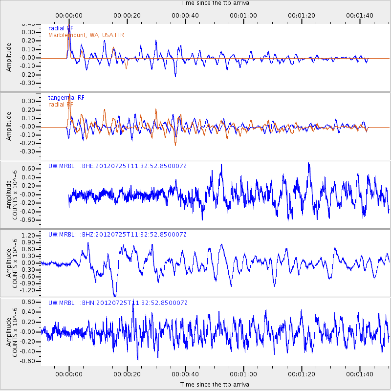
| Radial Match: |
89.159004 % |
| Radial Bump: |
400 |
| Transverse Match: |
81.622795 % |
| Transverse Bump: |
400 |
| SOD ConfigId: |
469095 |
| Insert Time: |
2013-02-22 00:46:15.099 +0000 |
| GWidth: |
2.5 |
| Max Bumps: |
400 |
| Tol: |
0.001 |
|
Signal To Noise
| Channel | StoN | STA | LTA |
| UW:MRBL: :BHZ:20120725T11:32:52.850007Z | 3.2996206 | 1.9098347E-7 | 5.7880435E-8 |
| UW:MRBL: :BHN:20120725T11:32:52.850007Z | 0.78329635 | 5.8304877E-8 | 7.443528E-8 |
| UW:MRBL: :BHE:20120725T11:32:52.850007Z | 1.2438663 | 1.0173281E-7 | 8.1787576E-8 |
| Arrivals |
| Ps | 4.4 SECOND |
| PpPs | 12 SECOND |
| PsPs/PpSs | 17 SECOND |


