You are here: Home > Network List > UW - Pacific Northwest Regional Seismic Network Stations List
> Station UMAT Pilot Rock, OR, USA > Earthquake Result Viewer
UMAT Pilot Rock, OR, USA - Earthquake Result Viewer
| Earthquake location: |
Solomon Islands |
| Earthquake latitude/longitude: |
-9.7/159.7 |
| Earthquake time(UTC): |
2012/07/25 (207) 11:20:27 GMT |
| Earthquake Depth: |
20 km |
| Earthquake Magnitude: |
6.4 MB, 6.5 MS, 6.4 MW, 6.3 MW |
| Earthquake Catalog/Contributor: |
WHDF/NEIC |
|
| Network: |
UW Pacific Northwest Regional Seismic Network |
| Station: |
UMAT Pilot Rock, OR, USA |
| Lat/Lon: |
45.29 N/118.96 W |
| Elevation: |
1318 m |
|
| Distance: |
90.8 deg |
| Az: |
44.256 deg |
| Baz: |
257.081 deg |
| Ray Param: |
0.041648302 |
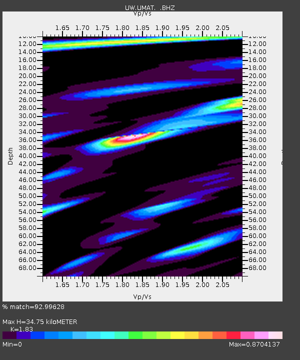
| Estimated Moho Depth: |
34.75 km |
| Estimated Crust Vp/Vs: |
1.83 |
| Assumed Crust Vp: |
6.571 km/s |
| Estimated Crust Vs: |
3.591 km/s |
| Estimated Crust Poisson's Ratio: |
0.29 |
|
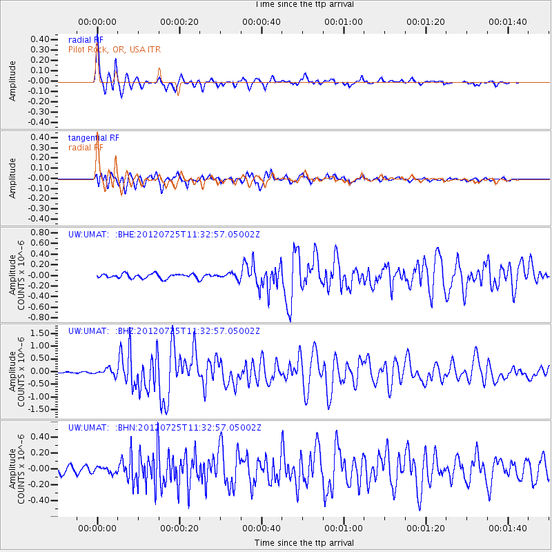
| Radial Match: |
92.99628 % |
| Radial Bump: |
317 |
| Transverse Match: |
88.4228 % |
| Transverse Bump: |
400 |
| SOD ConfigId: |
469095 |
| Insert Time: |
2013-02-22 00:46:25.032 +0000 |
| GWidth: |
2.5 |
| Max Bumps: |
400 |
| Tol: |
0.001 |
|
Signal To Noise
| Channel | StoN | STA | LTA |
| UW:UMAT: :BHZ:20120725T11:32:57.05002Z | 3.0486848 | 1.317818E-7 | 4.3225786E-8 |
| UW:UMAT: :BHN:20120725T11:32:57.05002Z | 0.8584551 | 3.698296E-8 | 4.308083E-8 |
| UW:UMAT: :BHE:20120725T11:32:57.05002Z | 1.3164855 | 5.5913375E-8 | 4.24717E-8 |
| Arrivals |
| Ps | 4.5 SECOND |
| PpPs | 15 SECOND |
| PsPs/PpSs | 19 SECOND |


