You are here: Home > Network List > CI - Caltech Regional Seismic Network Stations List
> Station TIN Tinemaha, Big Pine, CA, USA > Earthquake Result Viewer
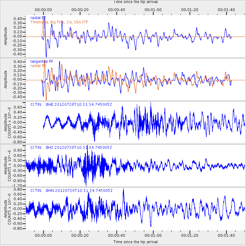
TIN Tinemaha, Big Pine, CA, USA - Earthquake Result Viewer
*The percent match for this event was below the threshold and hence no stack was calculated.
| Earthquake location: |
Tonga Islands |
| Earthquake latitude/longitude: |
-21.0/-174.5 |
| Earthquake time(UTC): |
2012/07/26 (208) 10:20:05 GMT |
| Earthquake Depth: |
10 km |
| Earthquake Magnitude: |
5.5 MW, 5.3 MS, 5.4 MB, 5.6 MW |
| Earthquake Catalog/Contributor: |
WHDF/NEIC |
|
| Network: |
CI Caltech Regional Seismic Network |
| Station: |
TIN Tinemaha, Big Pine, CA, USA |
| Lat/Lon: |
37.05 N/118.23 W |
| Elevation: |
1197 m |
|
| Distance: |
78.4 deg |
| Az: |
42.778 deg |
| Baz: |
232.481 deg |
| Ray Param: |
$rayparam |
*The percent match for this event was below the threshold and hence was not used in the summary stack. |
|
| Radial Match: |
65.43479 % |
| Radial Bump: |
400 |
| Transverse Match: |
55.768112 % |
| Transverse Bump: |
400 |
| SOD ConfigId: |
469095 |
| Insert Time: |
2013-02-22 00:51:59.003 +0000 |
| GWidth: |
2.5 |
| Max Bumps: |
400 |
| Tol: |
0.001 |
|
Signal To Noise
| Channel | StoN | STA | LTA |
| CI:TIN: :BHZ:20120726T10:31:34.745005Z | 1.8162464 | 2.4111282E-7 | 1.3275337E-7 |
| CI:TIN: :BHN:20120726T10:31:34.745005Z | 1.1554611 | 1.6883467E-7 | 1.4611888E-7 |
| CI:TIN: :BHE:20120726T10:31:34.745005Z | 0.977252 | 1.473754E-7 | 1.5080593E-7 |
| Arrivals |
| Ps | |
| PpPs | |
| PsPs/PpSs | |


