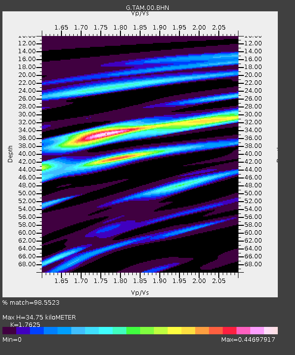
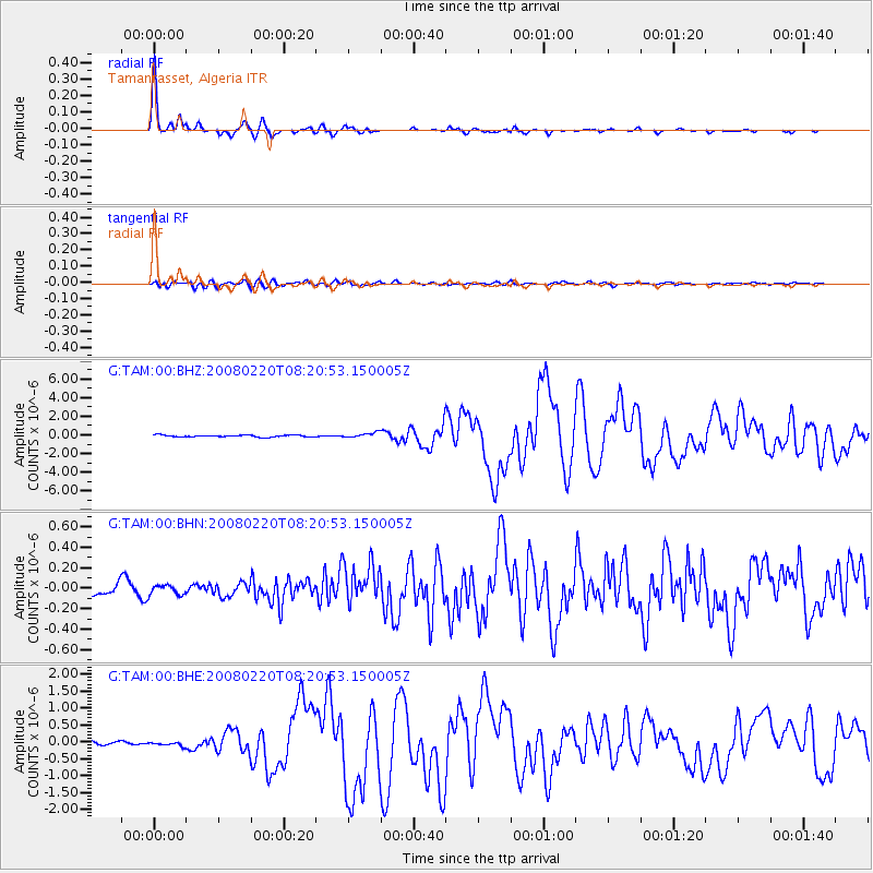
TAM Tamanrasset, Algeria - Earthquake Result Viewer

Earthquake location: Off W Coast Of Northern Sumatra
Earthquake latitude/longitude: 2.8/96.0
Earthquake time(UTC): 2008/02/20 (051) 08:08:30 GMT
Earthquake Depth: 26 km
Earthquake Magnitude: 6.5 MB, 7.5 MS, 7.4 MW, 7.4 MW
Earthquake Catalog/Contributor: WHDF/NEIC
Network: G GEOSCOPE
Station: TAM Tamanrasset, Algeria
Lat/Lon: 22.79 N/5.53 E
Elevation: 1377 m
Distance: 89.3 deg
Az: 292.649 deg
Baz: 87.294 deg
Ray Param: 0.041890744
Estimated Moho Depth: 34.75 km
Estimated Crust Vp/Vs: 1.76
Assumed Crust Vp: 6.61 km/s
Estimated Crust Vs: 3.75 km/s
Estimated Crust Poisson's Ratio: 0.26
Radial Match: 98.5523 %
Radial Bump: 222
Transverse Match: 83.6745 %
Transverse Bump: 400
SOD ConfigId: 2564
Insert Time: 2010-02-27 00:24:26.902 +0000
GWidth: 2.5
Max Bumps: 400
Tol: 0.001

Signal To Noise

ChannelStoNSTALTA
G:TAM:00:BHN:20080220T08:20:53.150005Z0.98115634.7620794E-84.853538E-8
G:TAM:00:BHE:20080220T08:20:53.150005Z0.795148735.661709E-87.120315E-8
G:TAM:00:BHZ:20080220T08:20:53.150005Z2.8053182.6716464E-79.5235066E-8
Arrivals
Ps4.1 SECOND
PpPs14 SECOND
PsPs/PpSs18 SECOND