You are here: Home > Network List > TA - USArray Transportable Network (new EarthScope stations) Stations List
> Station W39A Magazine, AR, USA > Earthquake Result Viewer
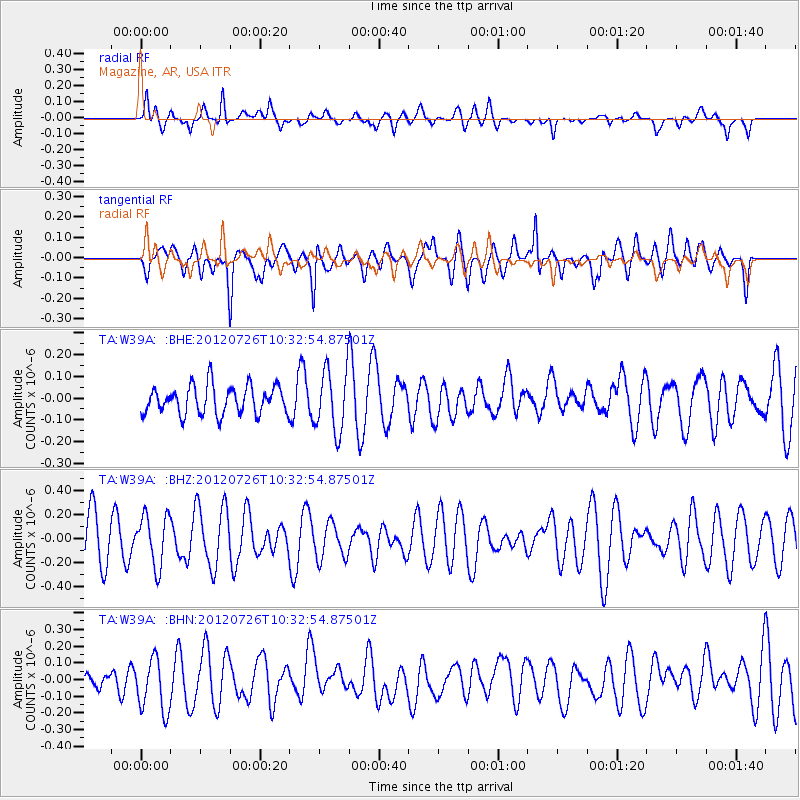
W39A Magazine, AR, USA - Earthquake Result Viewer
*The percent match for this event was below the threshold and hence no stack was calculated.
| Earthquake location: |
Tonga Islands |
| Earthquake latitude/longitude: |
-21.0/-174.5 |
| Earthquake time(UTC): |
2012/07/26 (208) 10:20:05 GMT |
| Earthquake Depth: |
10 km |
| Earthquake Magnitude: |
5.5 MW, 5.3 MS, 5.4 MB, 5.6 MW |
| Earthquake Catalog/Contributor: |
WHDF/NEIC |
|
| Network: |
TA USArray Transportable Network (new EarthScope stations) |
| Station: |
W39A Magazine, AR, USA |
| Lat/Lon: |
35.20 N/93.78 W |
| Elevation: |
162 m |
|
| Distance: |
94.6 deg |
| Az: |
54.186 deg |
| Baz: |
247.678 deg |
| Ray Param: |
$rayparam |
*The percent match for this event was below the threshold and hence was not used in the summary stack. |
|
| Radial Match: |
53.362293 % |
| Radial Bump: |
400 |
| Transverse Match: |
57.821022 % |
| Transverse Bump: |
400 |
| SOD ConfigId: |
469095 |
| Insert Time: |
2013-02-22 00:54:35.446 +0000 |
| GWidth: |
2.5 |
| Max Bumps: |
400 |
| Tol: |
0.001 |
|
Signal To Noise
| Channel | StoN | STA | LTA |
| TA:W39A: :BHZ:20120726T10:32:54.87501Z | 1.1693473 | 2.1224268E-7 | 1.8150526E-7 |
| TA:W39A: :BHN:20120726T10:32:54.87501Z | 1.5548387 | 1.6118632E-7 | 1.0366756E-7 |
| TA:W39A: :BHE:20120726T10:32:54.87501Z | 2.2409272 | 1.4435194E-7 | 6.441617E-8 |
| Arrivals |
| Ps | |
| PpPs | |
| PsPs/PpSs | |


