You are here: Home > Network List > TA - USArray Transportable Network (new EarthScope stations) Stations List
> Station P41A Barry, Barry, IL, USA > Earthquake Result Viewer
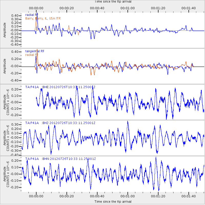
P41A Barry, Barry, IL, USA - Earthquake Result Viewer
*The percent match for this event was below the threshold and hence no stack was calculated.
| Earthquake location: |
Tonga Islands |
| Earthquake latitude/longitude: |
-21.0/-174.5 |
| Earthquake time(UTC): |
2012/07/26 (208) 10:20:05 GMT |
| Earthquake Depth: |
10 km |
| Earthquake Magnitude: |
5.5 MW, 5.3 MS, 5.4 MB, 5.6 MW |
| Earthquake Catalog/Contributor: |
WHDF/NEIC |
|
| Network: |
TA USArray Transportable Network (new EarthScope stations) |
| Station: |
P41A Barry, Barry, IL, USA |
| Lat/Lon: |
39.67 N/91.06 W |
| Elevation: |
215 m |
|
| Distance: |
98.3 deg |
| Az: |
50.788 deg |
| Baz: |
249.711 deg |
| Ray Param: |
$rayparam |
*The percent match for this event was below the threshold and hence was not used in the summary stack. |
|
| Radial Match: |
46.623352 % |
| Radial Bump: |
400 |
| Transverse Match: |
51.085014 % |
| Transverse Bump: |
400 |
| SOD ConfigId: |
469095 |
| Insert Time: |
2013-02-22 00:55:16.438 +0000 |
| GWidth: |
2.5 |
| Max Bumps: |
400 |
| Tol: |
0.001 |
|
Signal To Noise
| Channel | StoN | STA | LTA |
| TA:P41A: :BHZ:20120726T10:33:11.25001Z | 0.6289313 | 8.953912E-8 | 1.4236711E-7 |
| TA:P41A: :BHN:20120726T10:33:11.25001Z | 0.5299568 | 4.4079428E-8 | 8.317551E-8 |
| TA:P41A: :BHE:20120726T10:33:11.25001Z | 0.8820456 | 6.790931E-8 | 7.69907E-8 |
| Arrivals |
| Ps | |
| PpPs | |
| PsPs/PpSs | |


