You are here: Home > Network List > AZ - ANZA Regional Network Stations List
> Station SMER AZ.SMER > Earthquake Result Viewer
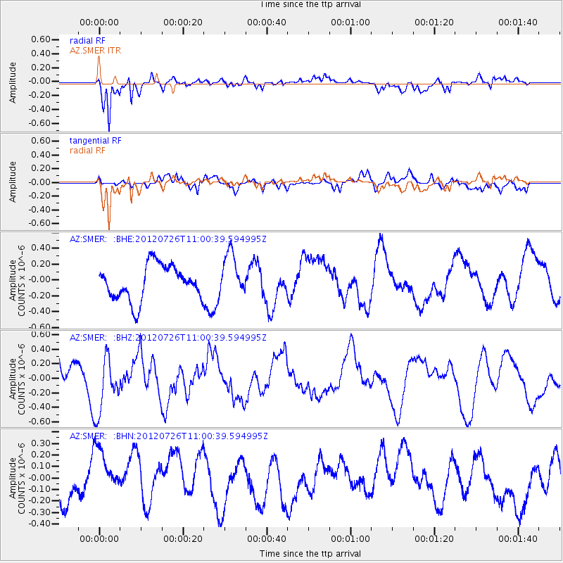
SMER AZ.SMER - Earthquake Result Viewer
*The percent match for this event was below the threshold and hence no stack was calculated.
| Earthquake location: |
Southeast Of Loyalty Islands |
| Earthquake latitude/longitude: |
-21.1/169.5 |
| Earthquake time(UTC): |
2012/07/26 (208) 10:48:22 GMT |
| Earthquake Depth: |
33 km |
| Earthquake Magnitude: |
5.6 MW, 5.4 MS, 5.2 MB |
| Earthquake Catalog/Contributor: |
WHDF/NEIC |
|
| Network: |
AZ ANZA Regional Network |
| Station: |
SMER AZ.SMER |
| Lat/Lon: |
33.46 N/117.17 W |
| Elevation: |
355 m |
|
| Distance: |
88.4 deg |
| Az: |
53.237 deg |
| Baz: |
243.482 deg |
| Ray Param: |
$rayparam |
*The percent match for this event was below the threshold and hence was not used in the summary stack. |
|
| Radial Match: |
88.1925 % |
| Radial Bump: |
400 |
| Transverse Match: |
56.037548 % |
| Transverse Bump: |
400 |
| SOD ConfigId: |
469095 |
| Insert Time: |
2013-02-22 00:58:14.408 +0000 |
| GWidth: |
2.5 |
| Max Bumps: |
400 |
| Tol: |
0.001 |
|
Signal To Noise
| Channel | StoN | STA | LTA |
| AZ:SMER: :BHZ:20120726T11:00:39.594995Z | 1.6082555 | 3.8509071E-7 | 2.3944622E-7 |
| AZ:SMER: :BHN:20120726T11:00:39.594995Z | 1.856438 | 2.571059E-7 | 1.384942E-7 |
| AZ:SMER: :BHE:20120726T11:00:39.594995Z | 1.2861099 | 2.7751187E-7 | 2.1577615E-7 |
| Arrivals |
| Ps | |
| PpPs | |
| PsPs/PpSs | |


