You are here: Home > Network List > UW - Pacific Northwest Regional Seismic Network Stations List
> Station HOOD Mt Hood Meadows, OR CREST BB SMO > Earthquake Result Viewer
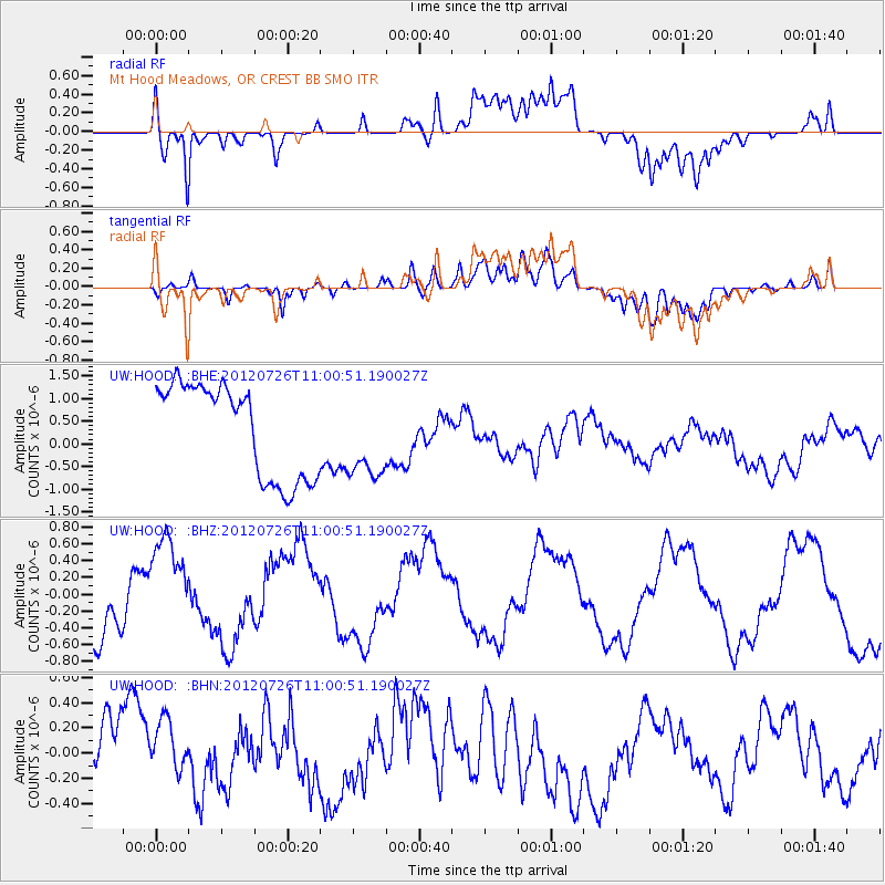
HOOD Mt Hood Meadows, OR CREST BB SMO - Earthquake Result Viewer
*The percent match for this event was below the threshold and hence no stack was calculated.
| Earthquake location: |
Southeast Of Loyalty Islands |
| Earthquake latitude/longitude: |
-21.1/169.5 |
| Earthquake time(UTC): |
2012/07/26 (208) 10:48:22 GMT |
| Earthquake Depth: |
33 km |
| Earthquake Magnitude: |
5.6 MW, 5.4 MS, 5.2 MB |
| Earthquake Catalog/Contributor: |
WHDF/NEIC |
|
| Network: |
UW Pacific Northwest Regional Seismic Network |
| Station: |
HOOD Mt Hood Meadows, OR CREST BB SMO |
| Lat/Lon: |
45.32 N/121.65 W |
| Elevation: |
1520 m |
|
| Distance: |
90.9 deg |
| Az: |
41.149 deg |
| Baz: |
240.561 deg |
| Ray Param: |
$rayparam |
*The percent match for this event was below the threshold and hence was not used in the summary stack. |
|
| Radial Match: |
76.27874 % |
| Radial Bump: |
400 |
| Transverse Match: |
66.72459 % |
| Transverse Bump: |
400 |
| SOD ConfigId: |
469095 |
| Insert Time: |
2013-02-22 01:00:48.194 +0000 |
| GWidth: |
2.5 |
| Max Bumps: |
400 |
| Tol: |
0.001 |
|
Signal To Noise
| Channel | StoN | STA | LTA |
| UW:HOOD: :BHZ:20120726T11:00:51.190027Z | 1.6049837 | 5.835447E-7 | 3.6358296E-7 |
| UW:HOOD: :BHN:20120726T11:00:51.190027Z | 1.0543187 | 2.0315068E-7 | 1.9268433E-7 |
| UW:HOOD: :BHE:20120726T11:00:51.190027Z | 0.8759041 | 9.0454193E-7 | 1.0326952E-6 |
| Arrivals |
| Ps | |
| PpPs | |
| PsPs/PpSs | |


