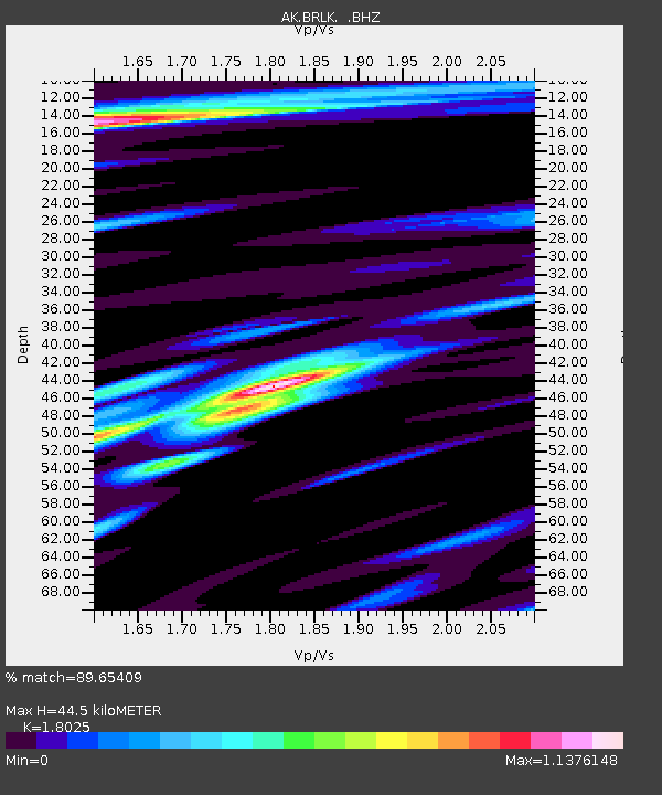
BRLK Bradley Lake - Earthquake Result Viewer

Earthquake location: New Ireland Region, P.N.G.
Earthquake latitude/longitude: -4.7/153.2
Earthquake time(UTC): 2012/07/28 (210) 20:03:56 GMT
Earthquake Depth: 41 km
Earthquake Magnitude: 6.1 MB, 6.3 MS, 6.5 MW, 6.5 MW
Earthquake Catalog/Contributor: WHDF/NEIC
Network: AK Alaska Regional Network
Station: BRLK Bradley Lake
Lat/Lon: 59.75 N/150.91 W
Elevation: 409 m
Distance: 77.7 deg
Az: 25.418 deg
Baz: 237.674 deg
Ray Param: 0.05008835
Estimated Moho Depth: 44.5 km
Estimated Crust Vp/Vs: 1.80
Assumed Crust Vp: 6.24 km/s
Estimated Crust Vs: 3.462 km/s
Estimated Crust Poisson's Ratio: 0.28
Radial Match: 89.65409 %
Radial Bump: 400
Transverse Match: 80.971436 %
Transverse Bump: 400
SOD ConfigId: 469095
Insert Time: 2013-02-22 01:02:13.547 +0000
GWidth: 2.5
Max Bumps: 400
Tol: 0.001

Signal To Noise

ChannelStoNSTALTA
AK:BRLK: :BHZ:20120728T20:15:18.148022Z13.6272842.054043E-61.5073019E-7
AK:BRLK: :BHN:20120728T20:15:18.148022Z2.46720894.3643914E-71.768959E-7
AK:BRLK: :BHE:20120728T20:15:18.148022Z5.5256688.1933877E-71.4827869E-7
Arrivals
Ps5.9 SECOND
PpPs19 SECOND
PsPs/PpSs25 SECOND