You are here: Home > Network List > AK - Alaska Regional Network Stations List
> Station YAH Yahtse, AK, USA > Earthquake Result Viewer
YAH Yahtse, AK, USA - Earthquake Result Viewer
| Earthquake location: |
New Ireland Region, P.N.G. |
| Earthquake latitude/longitude: |
-4.7/153.2 |
| Earthquake time(UTC): |
2012/07/28 (210) 20:03:56 GMT |
| Earthquake Depth: |
41 km |
| Earthquake Magnitude: |
6.1 MB, 6.3 MS, 6.5 MW, 6.5 MW |
| Earthquake Catalog/Contributor: |
WHDF/NEIC |
|
| Network: |
AK Alaska Regional Network |
| Station: |
YAH Yahtse, AK, USA |
| Lat/Lon: |
60.36 N/141.75 W |
| Elevation: |
2125 m |
|
| Distance: |
82.0 deg |
| Az: |
27.078 deg |
| Baz: |
245.891 deg |
| Ray Param: |
0.047116596 |
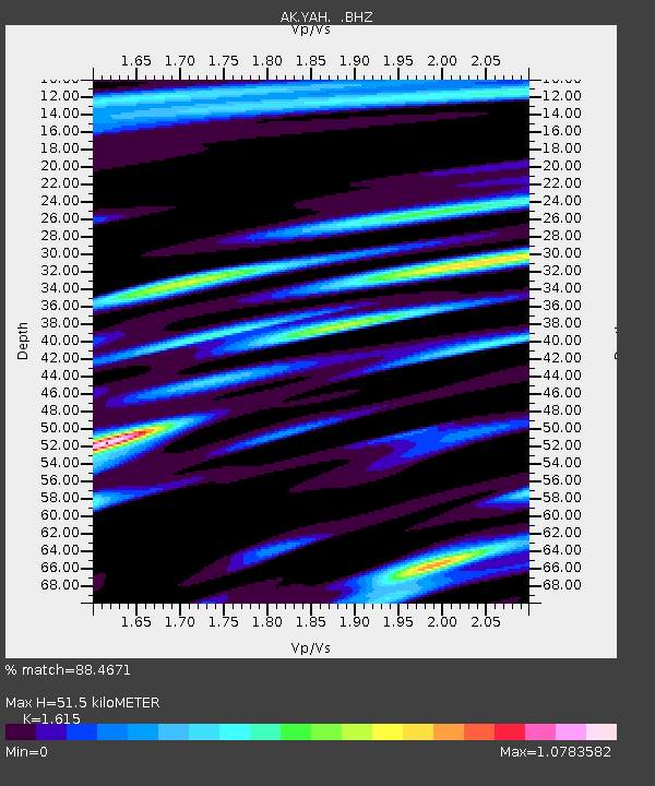
| Estimated Moho Depth: |
51.5 km |
| Estimated Crust Vp/Vs: |
1.62 |
| Assumed Crust Vp: |
6.566 km/s |
| Estimated Crust Vs: |
4.066 km/s |
| Estimated Crust Poisson's Ratio: |
0.19 |
|
| Radial Match: |
88.4671 % |
| Radial Bump: |
400 |
| Transverse Match: |
85.53314 % |
| Transverse Bump: |
400 |
| SOD ConfigId: |
469095 |
| Insert Time: |
2013-02-22 01:02:52.241 +0000 |
| GWidth: |
2.5 |
| Max Bumps: |
400 |
| Tol: |
0.001 |
|

Signal To Noise
| Channel | StoN | STA | LTA |
| AK:YAH: :BHZ:20120728T20:15:41.487988Z | 26.40185 | 1.7279187E-6 | 6.544688E-8 |
| AK:YAH: :BHN:20120728T20:15:41.487988Z | 2.3445737 | 2.5252226E-7 | 1.07704984E-7 |
| AK:YAH: :BHE:20120728T20:15:41.487988Z | 10.870876 | 6.5445306E-7 | 6.020242E-8 |
| Arrivals |
| Ps | 5.0 SECOND |
| PpPs | 20 SECOND |
| PsPs/PpSs | 25 SECOND |


