You are here: Home > Network List > G - GEOSCOPE Stations List
> Station TAM Tamanrasset, Algeria > Earthquake Result Viewer
TAM Tamanrasset, Algeria - Earthquake Result Viewer
| Earthquake location: |
Sudan |
| Earthquake latitude/longitude: |
5.0/32.1 |
| Earthquake time(UTC): |
1990/05/20 (140) 02:21:59 GMT |
| Earthquake Depth: |
7.0 km |
| Earthquake Magnitude: |
6.6 MB, 7.2 MS |
| Earthquake Catalog/Contributor: |
WHDF/NEIC |
|
| Network: |
G GEOSCOPE |
| Station: |
TAM Tamanrasset, Algeria |
| Lat/Lon: |
22.79 N/5.53 E |
| Elevation: |
1377 m |
|
| Distance: |
31.2 deg |
| Az: |
307.042 deg |
| Baz: |
120.501 deg |
| Ray Param: |
0.07914728 |
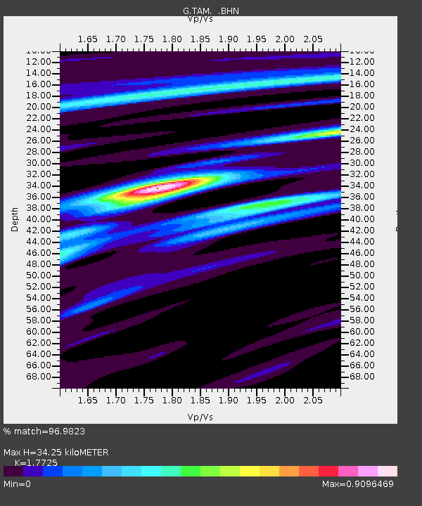
| Estimated Moho Depth: |
34.25 km |
| Estimated Crust Vp/Vs: |
1.77 |
| Assumed Crust Vp: |
6.61 km/s |
| Estimated Crust Vs: |
3.729 km/s |
| Estimated Crust Poisson's Ratio: |
0.27 |
|
| Radial Match: |
96.9823 % |
| Radial Bump: |
176 |
| Transverse Match: |
87.01486 % |
| Transverse Bump: |
400 |
| SOD ConfigId: |
16938 |
| Insert Time: |
2010-02-27 00:24:47.160 +0000 |
| GWidth: |
2.5 |
| Max Bumps: |
400 |
| Tol: |
0.001 |
|

Signal To Noise
| Channel | StoN | STA | LTA |
| G:TAM: :BHN:19900520T02:27:48.400012Z | 30.993315 | 1.6808854E-6 | 5.4233805E-8 |
| G:TAM: :BHE:19900520T02:27:48.400012Z | 39.99626 | 2.5868858E-6 | 6.467818E-8 |
| G:TAM: :BHZ:19900520T02:27:48.400012Z | 58.387463 | 4.9594914E-6 | 8.4941036E-8 |
| Arrivals |
| Ps | 4.4 SECOND |
| PpPs | 13 SECOND |
| PsPs/PpSs | 18 SECOND |


