You are here: Home > Network List > G - GEOSCOPE Stations List
> Station TAM Tamanrasset, Algeria > Earthquake Result Viewer
TAM Tamanrasset, Algeria - Earthquake Result Viewer

| Earthquake location: |
Northern Peru |
| Earthquake latitude/longitude: |
-6.0/-77.3 |
| Earthquake time(UTC): |
1990/05/30 (150) 02:34:07 GMT |
| Earthquake Depth: |
33 km |
| Earthquake Magnitude: |
6.0 MB, 6.4 MS, 6.6 UNKNOWN |
| Earthquake Catalog/Contributor: |
WHDF/NEIC |
|
| Network: |
G GEOSCOPE |
| Station: |
TAM Tamanrasset, Algeria |
| Lat/Lon: |
22.79 N/5.53 E |
| Elevation: |
1377 m |
|
| Distance: |
85.7 deg |
| Az: |
66.656 deg |
| Baz: |
261.674 deg |
| Ray Param: |
0.04453087 |
| Estimated Moho Depth: |
34.0 km |
| Estimated Crust Vp/Vs: |
1.77 |
| Assumed Crust Vp: |
6.61 km/s |
| Estimated Crust Vs: |
3.729 km/s |
| Estimated Crust Poisson's Ratio: |
0.27 |
|
| Radial Match: |
97.4378 % |
| Radial Bump: |
304 |
| Transverse Match: |
89.760155 % |
| Transverse Bump: |
400 |
| SOD ConfigId: |
16938 |
| Insert Time: |
2010-02-27 00:24:51.074 +0000 |
| GWidth: |
2.5 |
| Max Bumps: |
400 |
| Tol: |
0.001 |
|
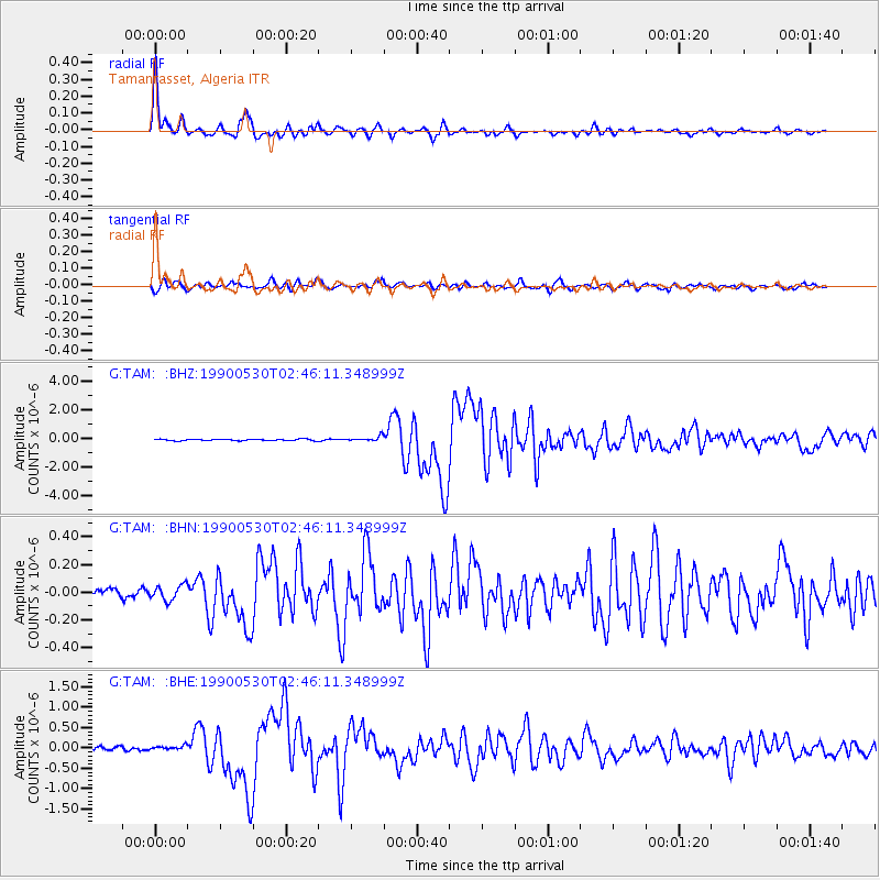
Signal To Noise
| Channel | StoN | STA | LTA |
| G:TAM: :BHN:19900530T02:46:11.348999Z | 1.5918931 | 5.348986E-8 | 3.3601417E-8 |
| G:TAM: :BHE:19900530T02:46:11.348999Z | 1.1214913 | 5.2667996E-8 | 4.6962466E-8 |
| G:TAM: :BHZ:19900530T02:46:11.348999Z | 3.204419 | 1.7036498E-7 | 5.316564E-8 |
| Arrivals |
| Ps | 4.1 SECOND |
| PpPs | 14 SECOND |
| PsPs/PpSs | 18 SECOND |


