You are here: Home > Network List > G - GEOSCOPE Stations List
> Station TAM Tamanrasset, Algeria > Earthquake Result Viewer
TAM Tamanrasset, Algeria - Earthquake Result Viewer
| Earthquake location: |
Pakistan |
| Earthquake latitude/longitude: |
27.4/65.8 |
| Earthquake time(UTC): |
1990/06/17 (168) 04:51:46 GMT |
| Earthquake Depth: |
19 km |
| Earthquake Magnitude: |
5.8 MB, 6.2 MS |
| Earthquake Catalog/Contributor: |
WHDF/NEIC |
|
| Network: |
G GEOSCOPE |
| Station: |
TAM Tamanrasset, Algeria |
| Lat/Lon: |
22.79 N/5.53 E |
| Elevation: |
1377 m |
|
| Distance: |
54.3 deg |
| Az: |
279.396 deg |
| Baz: |
71.847 deg |
| Ray Param: |
0.065505065 |
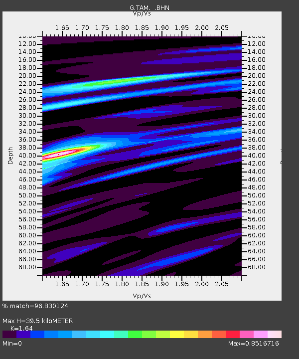
| Estimated Moho Depth: |
39.5 km |
| Estimated Crust Vp/Vs: |
1.64 |
| Assumed Crust Vp: |
6.61 km/s |
| Estimated Crust Vs: |
4.03 km/s |
| Estimated Crust Poisson's Ratio: |
0.20 |
|
| Radial Match: |
96.830124 % |
| Radial Bump: |
256 |
| Transverse Match: |
84.93649 % |
| Transverse Bump: |
400 |
| SOD ConfigId: |
16938 |
| Insert Time: |
2010-02-27 00:24:58.813 +0000 |
| GWidth: |
2.5 |
| Max Bumps: |
400 |
| Tol: |
0.001 |
|
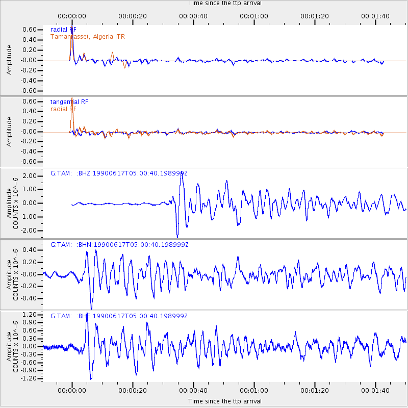
Signal To Noise
| Channel | StoN | STA | LTA |
| G:TAM: :BHN:19900617T05:00:40.198999Z | 3.8490465 | 1.1746707E-7 | 3.0518486E-8 |
| G:TAM: :BHE:19900617T05:00:40.198999Z | 4.4270005 | 3.10966E-7 | 7.024304E-8 |
| G:TAM: :BHZ:19900617T05:00:40.198999Z | 15.883785 | 6.8235676E-7 | 4.2959325E-8 |
| Arrivals |
| Ps | 4.1 SECOND |
| PpPs | 15 SECOND |
| PsPs/PpSs | 19 SECOND |


