You are here: Home > Network List > G - GEOSCOPE Stations List
> Station TAM Tamanrasset, Algeria > Earthquake Result Viewer
TAM Tamanrasset, Algeria - Earthquake Result Viewer
| Earthquake location: |
Western Iran |
| Earthquake latitude/longitude: |
37.0/49.4 |
| Earthquake time(UTC): |
1990/06/20 (171) 21:00:08 GMT |
| Earthquake Depth: |
10 km |
| Earthquake Magnitude: |
6.3 MB, 7.7 MS |
| Earthquake Catalog/Contributor: |
WHDF/NEIC |
|
| Network: |
G GEOSCOPE |
| Station: |
TAM Tamanrasset, Algeria |
| Lat/Lon: |
22.79 N/5.53 E |
| Elevation: |
1377 m |
|
| Distance: |
40.2 deg |
| Az: |
262.02 deg |
| Baz: |
59.265 deg |
| Ray Param: |
0.074507974 |
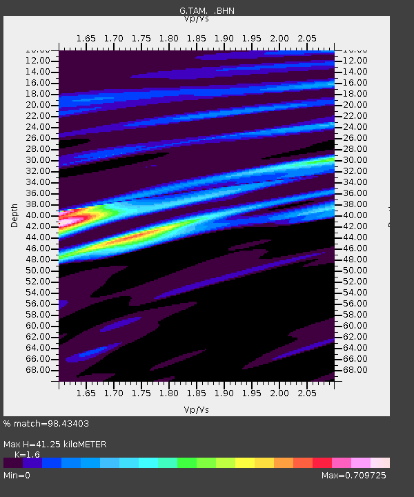
| Estimated Moho Depth: |
41.25 km |
| Estimated Crust Vp/Vs: |
1.60 |
| Assumed Crust Vp: |
6.61 km/s |
| Estimated Crust Vs: |
4.131 km/s |
| Estimated Crust Poisson's Ratio: |
0.18 |
|
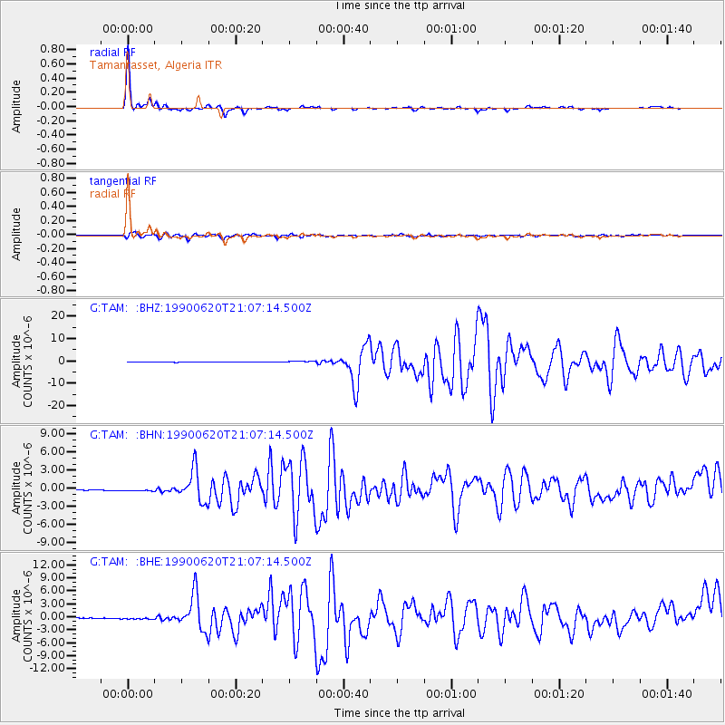
| Radial Match: |
98.43403 % |
| Radial Bump: |
154 |
| Transverse Match: |
92.33491 % |
| Transverse Bump: |
380 |
| SOD ConfigId: |
16938 |
| Insert Time: |
2010-02-27 00:25:00.351 +0000 |
| GWidth: |
2.5 |
| Max Bumps: |
400 |
| Tol: |
0.001 |
|
Signal To Noise
| Channel | StoN | STA | LTA |
| G:TAM: :BHN:19900620T21:07:14.500Z | 3.0483015 | 1.4097579E-7 | 4.6247322E-8 |
| G:TAM: :BHE:19900620T21:07:14.500Z | 3.2623844 | 2.2221211E-7 | 6.811341E-8 |
| G:TAM: :BHZ:19900620T21:07:14.500Z | 5.043943 | 3.5035237E-7 | 6.9460015E-8 |
| Arrivals |
| Ps | 4.1 SECOND |
| PpPs | 15 SECOND |
| PsPs/PpSs | 19 SECOND |


