You are here: Home > Network List > G - GEOSCOPE Stations List
> Station TAM Tamanrasset, Algeria > Earthquake Result Viewer
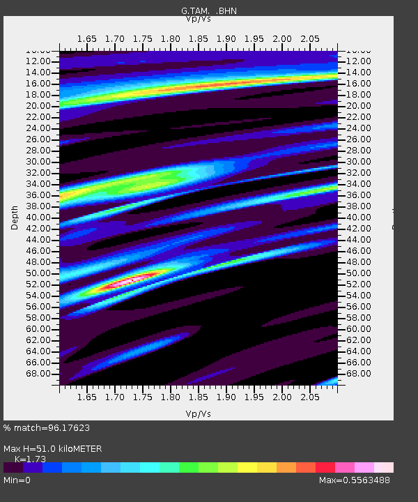
TAM Tamanrasset, Algeria - Earthquake Result Viewer
| Earthquake location: |
Sudan |
| Earthquake latitude/longitude: |
5.4/31.7 |
| Earthquake time(UTC): |
1990/07/09 (190) 15:11:19 GMT |
| Earthquake Depth: |
10 km |
| Earthquake Magnitude: |
6.0 MB, 6.4 MS, 6.6 UNKNOWN |
| Earthquake Catalog/Contributor: |
WHDF/NEIC |
|
| Network: |
G GEOSCOPE |
| Station: |
TAM Tamanrasset, Algeria |
| Lat/Lon: |
22.79 N/5.53 E |
| Elevation: |
1377 m |
|
| Distance: |
30.6 deg |
| Az: |
307.028 deg |
| Baz: |
120.531 deg |
| Ray Param: |
0.07928638 |
| Estimated Moho Depth: |
51.0 km |
| Estimated Crust Vp/Vs: |
1.73 |
| Assumed Crust Vp: |
6.61 km/s |
| Estimated Crust Vs: |
3.821 km/s |
| Estimated Crust Poisson's Ratio: |
0.25 |
|
| Radial Match: |
96.17623 % |
| Radial Bump: |
169 |
| Transverse Match: |
78.357605 % |
| Transverse Bump: |
400 |
| SOD ConfigId: |
16938 |
| Insert Time: |
2010-02-27 00:25:01.535 +0000 |
| GWidth: |
2.5 |
| Max Bumps: |
400 |
| Tol: |
0.001 |
|

Signal To Noise
| Channel | StoN | STA | LTA |
| G:TAM: :BHN:19900709T15:17:02.950012Z | 1.2451494 | 5.6013615E-8 | 4.498546E-8 |
| G:TAM: :BHE:19900709T15:17:02.950012Z | 0.89257437 | 6.940972E-8 | 7.776352E-8 |
| G:TAM: :BHZ:19900709T15:17:02.950012Z | 2.1585498 | 1.7183007E-7 | 7.96044E-8 |
| Arrivals |
| Ps | 6.1 SECOND |
| PpPs | 19 SECOND |
| PsPs/PpSs | 25 SECOND |


