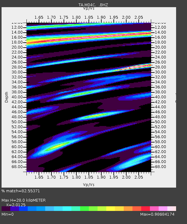
M04C Macdoel, CA, USA - Earthquake Result Viewer

Earthquake location: New Ireland Region, P.N.G.
Earthquake latitude/longitude: -4.7/153.2
Earthquake time(UTC): 2012/07/28 (210) 20:03:56 GMT
Earthquake Depth: 41 km
Earthquake Magnitude: 6.1 MB, 6.3 MS, 6.5 MW, 6.5 MW
Earthquake Catalog/Contributor: WHDF/NEIC
Network: TA USArray Transportable Network (new EarthScope stations)
Station: M04C Macdoel, CA, USA
Lat/Lon: 41.78 N/121.84 W
Elevation: 1391 m
Distance: 89.3 deg
Az: 48.167 deg
Baz: 263.22 deg
Ray Param: 0.041868743
Estimated Moho Depth: 28.0 km
Estimated Crust Vp/Vs: 2.01
Assumed Crust Vp: 6.566 km/s
Estimated Crust Vs: 3.263 km/s
Estimated Crust Poisson's Ratio: 0.34
Radial Match: 82.55371 %
Radial Bump: 400
Transverse Match: 75.15179 %
Transverse Bump: 400
SOD ConfigId: 469095
Insert Time: 2013-02-22 01:14:27.036 +0000
GWidth: 2.5
Max Bumps: 400
Tol: 0.001

Signal To Noise

ChannelStoNSTALTA
TA:M04C: :BHZ:20120728T20:16:17.649976Z14.8101838.197784E-75.5352352E-8
TA:M04C: :BHN:20120728T20:16:17.649976Z1.90993651.7039785E-78.92165E-8
TA:M04C: :BHE:20120728T20:16:17.649976Z2.5937382.5232742E-79.728331E-8
Arrivals
Ps4.4 SECOND
PpPs13 SECOND
PsPs/PpSs17 SECOND