You are here: Home > Network List > X812 - Deep Structure of Three Continental Sutures in Eastern North America Stations List
> Station QM15 Land Trust South, Maine, USA > Earthquake Result Viewer
QM15 Land Trust South, Maine, USA - Earthquake Result Viewer
| Earthquake location: |
Off Coast Of Jalisco, Mexico |
| Earthquake latitude/longitude: |
18.9/-107.4 |
| Earthquake time(UTC): |
2014/05/31 (151) 11:53:48 GMT |
| Earthquake Depth: |
10 km |
| Earthquake Magnitude: |
6.2 MWP, 6.6 MI |
| Earthquake Catalog/Contributor: |
NEIC PDE/NEIC COMCAT |
|
| Network: |
X8 Deep Structure of Three Continental Sutures in Eastern North America |
| Station: |
QM15 Land Trust South, Maine, USA |
| Lat/Lon: |
45.09 N/67.84 W |
| Elevation: |
151 m |
|
| Distance: |
42.0 deg |
| Az: |
42.475 deg |
| Baz: |
244.532 deg |
| Ray Param: |
0.07345612 |
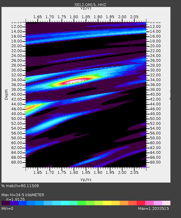
| Estimated Moho Depth: |
34.5 km |
| Estimated Crust Vp/Vs: |
1.81 |
| Assumed Crust Vp: |
6.419 km/s |
| Estimated Crust Vs: |
3.542 km/s |
| Estimated Crust Poisson's Ratio: |
0.28 |
|
| Radial Match: |
90.11509 % |
| Radial Bump: |
203 |
| Transverse Match: |
64.13122 % |
| Transverse Bump: |
400 |
| SOD ConfigId: |
3390531 |
| Insert Time: |
2019-04-12 03:01:27.015 +0000 |
| GWidth: |
2.5 |
| Max Bumps: |
400 |
| Tol: |
0.001 |
|

Signal To Noise
| Channel | StoN | STA | LTA |
| X8:QM15: :HHZ:20140531T12:01:08.170007Z | 5.013234 | 4.7257126E-7 | 9.426474E-8 |
| X8:QM15: :HHN:20140531T12:01:08.170007Z | 1.6710144 | 1.4812898E-7 | 8.864614E-8 |
| X8:QM15: :HHE:20140531T12:01:08.170007Z | 2.6186328 | 3.1459433E-7 | 1.2013687E-7 |
| Arrivals |
| Ps | 4.7 SECOND |
| PpPs | 14 SECOND |
| PsPs/PpSs | 19 SECOND |


