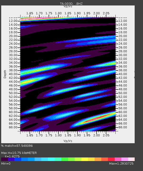
G03D McMinnville, OR, USA - Earthquake Result Viewer
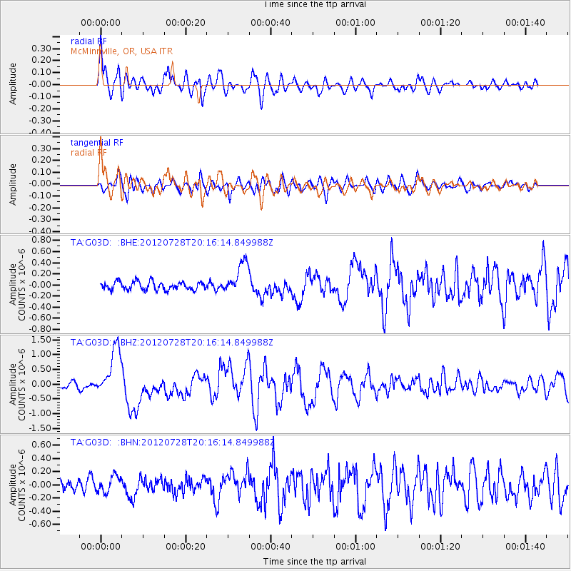
Earthquake location: New Ireland Region, P.N.G.
Earthquake latitude/longitude: -4.7/153.2
Earthquake time(UTC): 2012/07/28 (210) 20:03:56 GMT
Earthquake Depth: 41 km
Earthquake Magnitude: 6.1 MB, 6.3 MS, 6.5 MW, 6.5 MW
Earthquake Catalog/Contributor: WHDF/NEIC
Network: TA USArray Transportable Network (new EarthScope stations)
Station: G03D McMinnville, OR, USA
Lat/Lon: 45.21 N/123.26 W
Elevation: 222 m
Distance: 88.7 deg
Az: 44.635 deg
Baz: 262.183 deg
Ray Param: 0.042301573
Estimated Moho Depth: 10.75 km
Estimated Crust Vp/Vs: 1.63
Assumed Crust Vp: 6.566 km/s
Estimated Crust Vs: 4.035 km/s
Estimated Crust Poisson's Ratio: 0.20
Radial Match: 87.548096 %
Radial Bump: 400
Transverse Match: 76.45977 %
Transverse Bump: 400
SOD ConfigId: 469095
Insert Time: 2013-02-22 01:15:06.715 +0000
GWidth: 2.5
Max Bumps: 400
Tol: 0.001

Signal To Noise

ChannelStoNSTALTA
TA:G03D: :BHZ:20120728T20:16:14.849988Z10.7177718.553157E-77.980351E-8
TA:G03D: :BHN:20120728T20:16:14.849988Z1.37790681.2758946E-79.259658E-8
TA:G03D: :BHE:20120728T20:16:14.849988Z3.9333262.9142655E-77.409163E-8
Arrivals
Ps1.1 SECOND
PpPs4.2 SECOND
PsPs/PpSs5.3 SECOND