You are here: Home > Network List > X812 - Deep Structure of Three Continental Sutures in Eastern North America Stations List
> Station QM30 Fish River Lake, Maine, USA > Earthquake Result Viewer
QM30 Fish River Lake, Maine, USA - Earthquake Result Viewer
| Earthquake location: |
Off Coast Of Jalisco, Mexico |
| Earthquake latitude/longitude: |
18.9/-107.4 |
| Earthquake time(UTC): |
2014/05/31 (151) 11:53:48 GMT |
| Earthquake Depth: |
10 km |
| Earthquake Magnitude: |
6.2 MWP, 6.6 MI |
| Earthquake Catalog/Contributor: |
NEIC PDE/NEIC COMCAT |
|
| Network: |
X8 Deep Structure of Three Continental Sutures in Eastern North America |
| Station: |
QM30 Fish River Lake, Maine, USA |
| Lat/Lon: |
46.83 N/68.76 W |
| Elevation: |
262 m |
|
| Distance: |
42.2 deg |
| Az: |
39.726 deg |
| Baz: |
241.83 deg |
| Ray Param: |
0.073324494 |
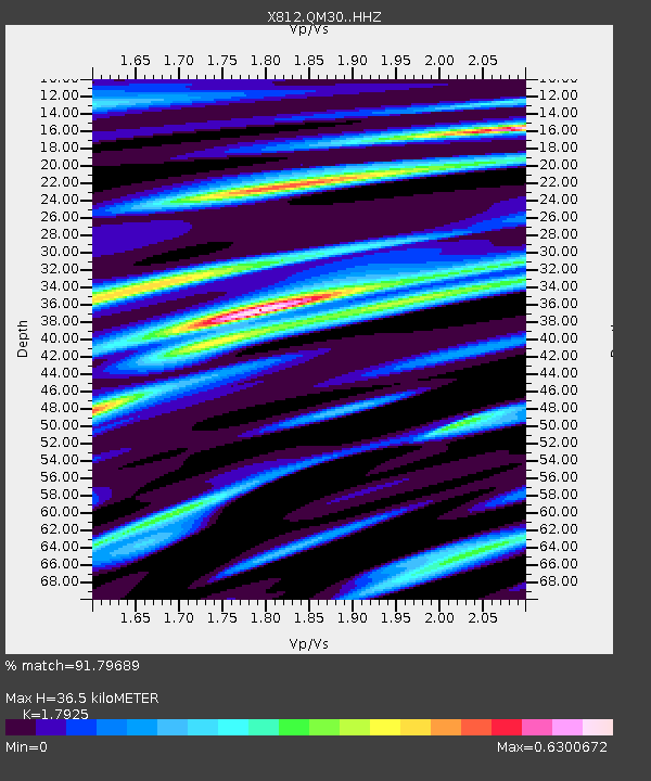
| Estimated Moho Depth: |
36.5 km |
| Estimated Crust Vp/Vs: |
1.79 |
| Assumed Crust Vp: |
6.419 km/s |
| Estimated Crust Vs: |
3.581 km/s |
| Estimated Crust Poisson's Ratio: |
0.27 |
|
| Radial Match: |
91.79689 % |
| Radial Bump: |
326 |
| Transverse Match: |
71.22544 % |
| Transverse Bump: |
400 |
| SOD ConfigId: |
3390531 |
| Insert Time: |
2019-04-12 03:01:28.521 +0000 |
| GWidth: |
2.5 |
| Max Bumps: |
400 |
| Tol: |
0.001 |
|

Signal To Noise
| Channel | StoN | STA | LTA |
| X8:QM30: :HHZ:20140531T12:01:09.920007Z | 4.1064987 | 5.188439E-7 | 1.2634702E-7 |
| X8:QM30: :HHN:20140531T12:01:09.920007Z | 1.974916 | 2.4148886E-7 | 1.2227804E-7 |
| X8:QM30: :HHE:20140531T12:01:09.920007Z | 1.8778617 | 3.06381E-7 | 1.6315418E-7 |
| Arrivals |
| Ps | 4.8 SECOND |
| PpPs | 15 SECOND |
| PsPs/PpSs | 20 SECOND |


