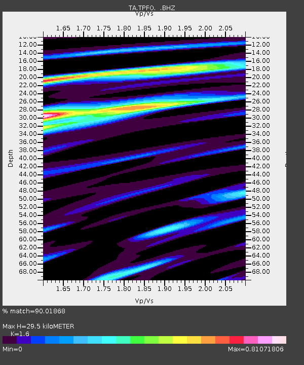
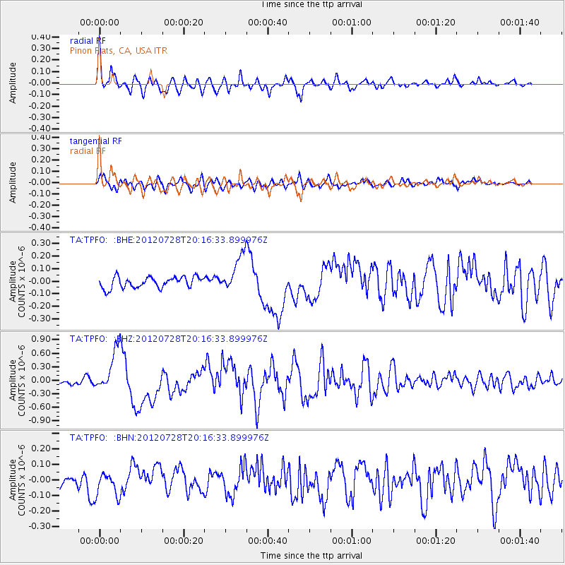
TPFO Pinon Flats, CA, USA - Earthquake Result Viewer

Earthquake location: New Ireland Region, P.N.G.
Earthquake latitude/longitude: -4.7/153.2
Earthquake time(UTC): 2012/07/28 (210) 20:03:56 GMT
Earthquake Depth: 41 km
Earthquake Magnitude: 6.1 MB, 6.3 MS, 6.5 MW, 6.5 MW
Earthquake Catalog/Contributor: WHDF/NEIC
Network: TA USArray Transportable Network (new EarthScope stations)
Station: TPFO Pinon Flats, CA, USA
Lat/Lon: 33.61 N/116.45 W
Elevation: 1275 m
Distance: 92.9 deg
Az: 56.677 deg
Baz: 266.346 deg
Ray Param: 0.041360565
Estimated Moho Depth: 29.5 km
Estimated Crust Vp/Vs: 1.60
Assumed Crust Vp: 6.264 km/s
Estimated Crust Vs: 3.915 km/s
Estimated Crust Poisson's Ratio: 0.18
Radial Match: 90.01868 %
Radial Bump: 400
Transverse Match: 73.7453 %
Transverse Bump: 400
SOD ConfigId: 469095
Insert Time: 2013-02-22 01:15:41.103 +0000
GWidth: 2.5
Max Bumps: 400
Tol: 0.001

Signal To Noise

ChannelStoNSTALTA
TA:TPFO: :BHZ:20120728T20:16:33.899976Z8.3836834.782541E-75.704582E-8
TA:TPFO: :BHN:20120728T20:16:33.899976Z1.16549487.533846E-86.464075E-8
TA:TPFO: :BHE:20120728T20:16:33.899976Z3.50620771.5518644E-74.4260478E-8
Arrivals
Ps2.9 SECOND
PpPs12 SECOND
PsPs/PpSs15 SECOND