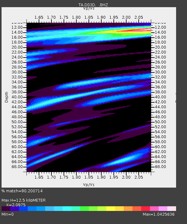
D03D Eldon, WA, USA - Earthquake Result Viewer

Earthquake location: New Ireland Region, P.N.G.
Earthquake latitude/longitude: -4.7/153.2
Earthquake time(UTC): 2012/07/28 (210) 20:03:56 GMT
Earthquake Depth: 41 km
Earthquake Magnitude: 6.1 MB, 6.3 MS, 6.5 MW, 6.5 MW
Earthquake Catalog/Contributor: WHDF/NEIC
Network: TA USArray Transportable Network (new EarthScope stations)
Station: D03D Eldon, WA, USA
Lat/Lon: 47.53 N/123.09 W
Elevation: 262 m
Distance: 89.2 deg
Az: 42.348 deg
Baz: 262.267 deg
Ray Param: 0.04198452
Estimated Moho Depth: 12.5 km
Estimated Crust Vp/Vs: 2.10
Assumed Crust Vp: 6.566 km/s
Estimated Crust Vs: 3.13 km/s
Estimated Crust Poisson's Ratio: 0.35
Radial Match: 90.200714 %
Radial Bump: 400
Transverse Match: 91.801994 %
Transverse Bump: 400
SOD ConfigId: 469095
Insert Time: 2013-02-22 01:16:29.644 +0000
GWidth: 2.5
Max Bumps: 400
Tol: 0.001

Signal To Noise

ChannelStoNSTALTA
TA:D03D: :BHZ:20120728T20:16:16.899976Z11.8418147.823845E-76.606965E-8
TA:D03D: :BHN:20120728T20:16:16.899976Z3.66574291.1964703E-73.2639228E-8
TA:D03D: :BHE:20120728T20:16:16.899976Z4.5082032.1956124E-74.870261E-8
Arrivals
Ps2.1 SECOND
PpPs5.8 SECOND
PsPs/PpSs7.9 SECOND