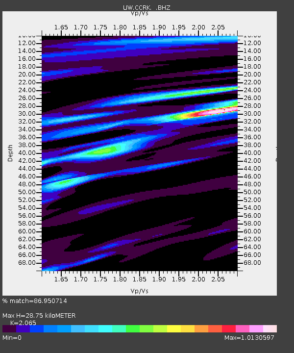
CCRK Sunnyside, WA, USA - Earthquake Result Viewer

Earthquake location: New Ireland Region, P.N.G.
Earthquake latitude/longitude: -4.7/153.2
Earthquake time(UTC): 2012/07/28 (210) 20:03:56 GMT
Earthquake Depth: 41 km
Earthquake Magnitude: 6.1 MB, 6.3 MS, 6.5 MW, 6.5 MW
Earthquake Catalog/Contributor: WHDF/NEIC
Network: UW Pacific Northwest Regional Seismic Network
Station: CCRK Sunnyside, WA, USA
Lat/Lon: 46.56 N/119.85 W
Elevation: 561 m
Distance: 91.3 deg
Az: 43.571 deg
Baz: 264.623 deg
Ray Param: 0.041609123
Estimated Moho Depth: 28.75 km
Estimated Crust Vp/Vs: 2.07
Assumed Crust Vp: 6.419 km/s
Estimated Crust Vs: 3.109 km/s
Estimated Crust Poisson's Ratio: 0.35
Radial Match: 86.950714 %
Radial Bump: 400
Transverse Match: 67.22966 %
Transverse Bump: 400
SOD ConfigId: 469095
Insert Time: 2013-02-22 01:19:53.906 +0000
GWidth: 2.5
Max Bumps: 400
Tol: 0.001

Signal To Noise

ChannelStoNSTALTA
UW:CCRK: :BHZ:20120728T20:16:26.550Z7.7415866.932474E-78.954849E-8
UW:CCRK: :BHN:20120728T20:16:26.550Z0.7985846.8515156E-88.5795804E-8
UW:CCRK: :BHE:20120728T20:16:26.550Z2.1476061.7148902E-77.9851254E-8
Arrivals
Ps4.9 SECOND
PpPs13 SECOND
PsPs/PpSs18 SECOND