You are here: Home > Network List > AV - Alaska Volcano Observatory Stations List
> Station SPCR Ckakachatna River, Mount Spurr, Alaska > Earthquake Result Viewer
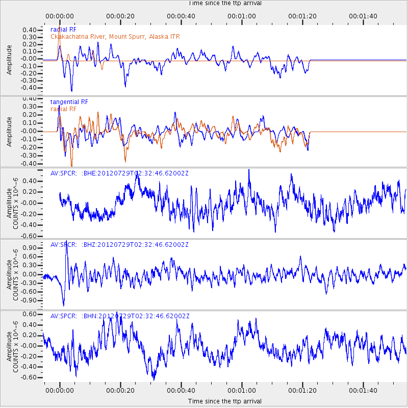
SPCR Ckakachatna River, Mount Spurr, Alaska - Earthquake Result Viewer
*The percent match for this event was below the threshold and hence no stack was calculated.
| Earthquake location: |
Myanmar |
| Earthquake latitude/longitude: |
22.9/94.3 |
| Earthquake time(UTC): |
2012/07/29 (211) 02:21:12 GMT |
| Earthquake Depth: |
75 km |
| Earthquake Magnitude: |
5.8 MB, 5.7 MW, 5.8 MW |
| Earthquake Catalog/Contributor: |
WHDF/NEIC |
|
| Network: |
AV Alaska Volcano Observatory |
| Station: |
SPCR Ckakachatna River, Mount Spurr, Alaska |
| Lat/Lon: |
61.20 N/152.21 W |
| Elevation: |
984 m |
|
| Distance: |
80.7 deg |
| Az: |
26.742 deg |
| Baz: |
301.057 deg |
| Ray Param: |
$rayparam |
*The percent match for this event was below the threshold and hence was not used in the summary stack. |
|
| Radial Match: |
50.599575 % |
| Radial Bump: |
342 |
| Transverse Match: |
49.8467 % |
| Transverse Bump: |
370 |
| SOD ConfigId: |
469095 |
| Insert Time: |
2013-02-22 01:22:57.223 +0000 |
| GWidth: |
2.5 |
| Max Bumps: |
400 |
| Tol: |
0.001 |
|
Signal To Noise
| Channel | StoN | STA | LTA |
| AV:SPCR: :BHZ:20120729T02:32:46.62002Z | 5.032275 | 5.238246E-7 | 1.04093E-7 |
| AV:SPCR: :BHN:20120729T02:32:46.62002Z | 1.2105014 | 2.0405415E-7 | 1.6856994E-7 |
| AV:SPCR: :BHE:20120729T02:32:46.62002Z | 1.0923799 | 1.8928726E-7 | 1.732797E-7 |
| Arrivals |
| Ps | |
| PpPs | |
| PsPs/PpSs | |


