You are here: Home > Network List > G - GEOSCOPE Stations List
> Station TAM Tamanrasset, Algeria > Earthquake Result Viewer
TAM Tamanrasset, Algeria - Earthquake Result Viewer
| Earthquake location: |
South Of Panama |
| Earthquake latitude/longitude: |
7.0/-78.2 |
| Earthquake time(UTC): |
1991/04/04 (094) 03:22:58 GMT |
| Earthquake Depth: |
39 km |
| Earthquake Magnitude: |
6.1 MB, 5.8 MS, 5.9 UNKNOWN, 5.9 MD |
| Earthquake Catalog/Contributor: |
WHDF/NEIC |
|
| Network: |
G GEOSCOPE |
| Station: |
TAM Tamanrasset, Algeria |
| Lat/Lon: |
22.79 N/5.53 E |
| Elevation: |
1377 m |
|
| Distance: |
81.5 deg |
| Az: |
68.027 deg |
| Baz: |
274.018 deg |
| Ray Param: |
0.04746246 |
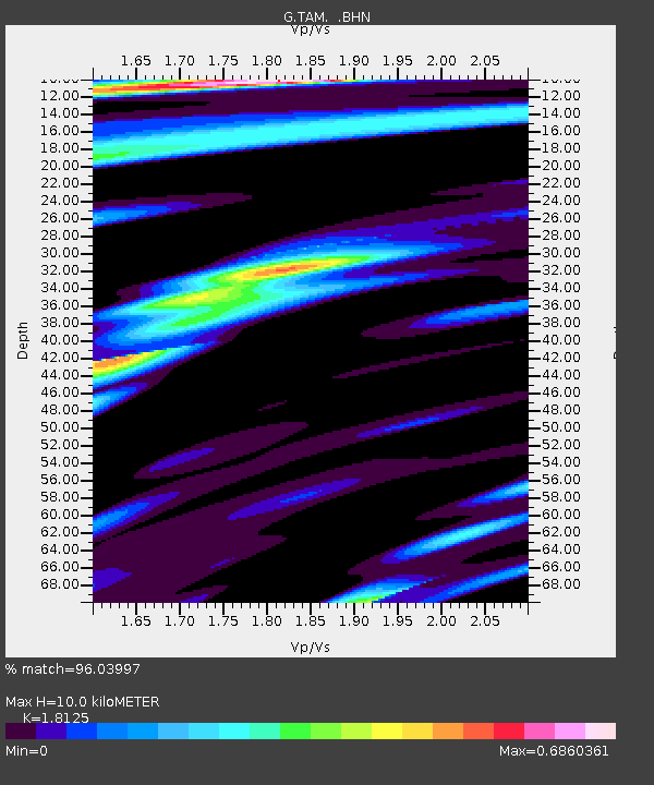
| Estimated Moho Depth: |
10.0 km |
| Estimated Crust Vp/Vs: |
1.81 |
| Assumed Crust Vp: |
6.61 km/s |
| Estimated Crust Vs: |
3.647 km/s |
| Estimated Crust Poisson's Ratio: |
0.28 |
|
| Radial Match: |
96.03997 % |
| Radial Bump: |
400 |
| Transverse Match: |
85.06806 % |
| Transverse Bump: |
400 |
| SOD ConfigId: |
16938 |
| Insert Time: |
2010-02-27 00:25:19.190 +0000 |
| GWidth: |
2.5 |
| Max Bumps: |
400 |
| Tol: |
0.001 |
|
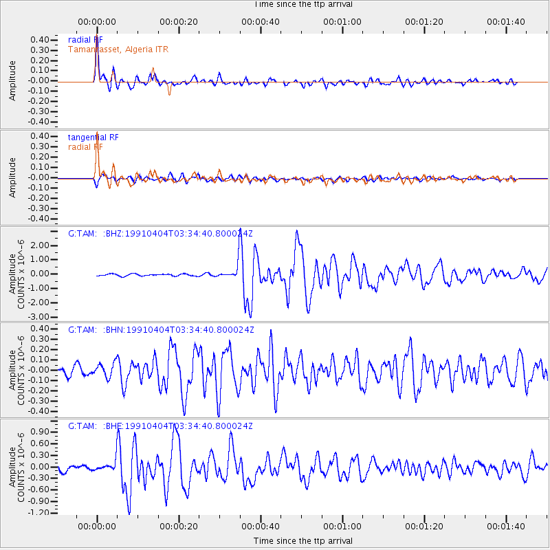
Signal To Noise
| Channel | StoN | STA | LTA |
| G:TAM: :BHN:19910404T03:34:40.800024Z | 1.2158513 | 6.9948015E-8 | 5.7530077E-8 |
| G:TAM: :BHE:19910404T03:34:40.800024Z | 1.7733381 | 1.5827179E-7 | 8.925077E-8 |
| G:TAM: :BHZ:19910404T03:34:40.800024Z | 8.854689 | 6.09149E-7 | 6.879395E-8 |
| Arrivals |
| Ps | 1.3 SECOND |
| PpPs | 4.1 SECOND |
| PsPs/PpSs | 5.4 SECOND |


