You are here: Home > Network List > G - GEOSCOPE Stations List
> Station TAM Tamanrasset, Algeria > Earthquake Result Viewer
TAM Tamanrasset, Algeria - Earthquake Result Viewer
| Earthquake location: |
Northern Peru |
| Earthquake latitude/longitude: |
-6.0/-77.1 |
| Earthquake time(UTC): |
1991/04/05 (095) 04:19:51 GMT |
| Earthquake Depth: |
33 km |
| Earthquake Magnitude: |
6.5 MB, 6.7 MS, 6.7 UNKNOWN |
| Earthquake Catalog/Contributor: |
WHDF/NEIC |
|
| Network: |
G GEOSCOPE |
| Station: |
TAM Tamanrasset, Algeria |
| Lat/Lon: |
22.79 N/5.53 E |
| Elevation: |
1377 m |
|
| Distance: |
85.5 deg |
| Az: |
66.637 deg |
| Baz: |
261.678 deg |
| Ray Param: |
0.044671714 |
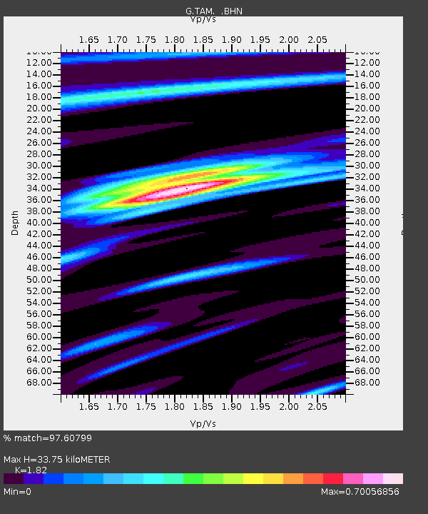
| Estimated Moho Depth: |
33.75 km |
| Estimated Crust Vp/Vs: |
1.82 |
| Assumed Crust Vp: |
6.61 km/s |
| Estimated Crust Vs: |
3.632 km/s |
| Estimated Crust Poisson's Ratio: |
0.28 |
|
| Radial Match: |
97.60799 % |
| Radial Bump: |
296 |
| Transverse Match: |
88.50263 % |
| Transverse Bump: |
400 |
| SOD ConfigId: |
16938 |
| Insert Time: |
2010-02-27 00:25:23.003 +0000 |
| GWidth: |
2.5 |
| Max Bumps: |
400 |
| Tol: |
0.001 |
|
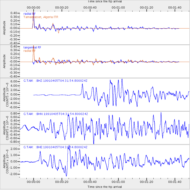
Signal To Noise
| Channel | StoN | STA | LTA |
| G:TAM: :BHN:19910405T04:31:54.800024Z | 1.6308105 | 1.196387E-7 | 7.336149E-8 |
| G:TAM: :BHE:19910405T04:31:54.800024Z | 8.209351 | 5.299354E-7 | 6.455266E-8 |
| G:TAM: :BHZ:19910405T04:31:54.800024Z | 16.797009 | 1.6419716E-6 | 9.775382E-8 |
| Arrivals |
| Ps | 4.3 SECOND |
| PpPs | 14 SECOND |
| PsPs/PpSs | 18 SECOND |


