You are here: Home > Network List > G - GEOSCOPE Stations List
> Station TAM Tamanrasset, Algeria > Earthquake Result Viewer
TAM Tamanrasset, Algeria - Earthquake Result Viewer

| Earthquake location: |
Costa Rica |
| Earthquake latitude/longitude: |
9.7/-83.1 |
| Earthquake time(UTC): |
1991/04/22 (112) 21:56:51 GMT |
| Earthquake Depth: |
10 km |
| Earthquake Magnitude: |
6.6 MB, 7.5 MS, 7.4 UNKNOWN |
| Earthquake Catalog/Contributor: |
WHDF/NEIC |
|
| Network: |
G GEOSCOPE |
| Station: |
TAM Tamanrasset, Algeria |
| Lat/Lon: |
22.79 N/5.53 E |
| Elevation: |
1377 m |
|
| Distance: |
85.0 deg |
| Az: |
67.826 deg |
| Baz: |
278.362 deg |
| Ray Param: |
0.04504801 |
| Estimated Moho Depth: |
33.5 km |
| Estimated Crust Vp/Vs: |
1.77 |
| Assumed Crust Vp: |
6.61 km/s |
| Estimated Crust Vs: |
3.734 km/s |
| Estimated Crust Poisson's Ratio: |
0.27 |
|
| Radial Match: |
98.52256 % |
| Radial Bump: |
294 |
| Transverse Match: |
92.12269 % |
| Transverse Bump: |
400 |
| SOD ConfigId: |
16938 |
| Insert Time: |
2010-02-27 00:25:24.477 +0000 |
| GWidth: |
2.5 |
| Max Bumps: |
400 |
| Tol: |
0.001 |
|
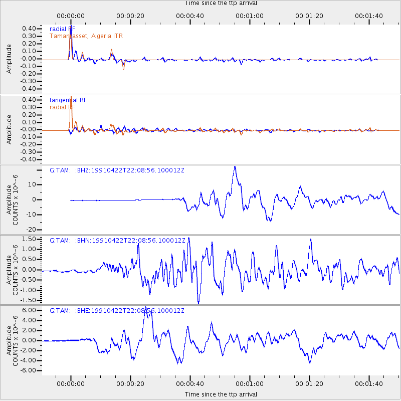
Signal To Noise
| Channel | StoN | STA | LTA |
| G:TAM: :BHN:19910422T22:08:56.100012Z | 1.4541968 | 5.5621836E-8 | 3.824918E-8 |
| G:TAM: :BHE:19910422T22:08:56.100012Z | 4.0975747 | 2.687546E-7 | 6.55887E-8 |
| G:TAM: :BHZ:19910422T22:08:56.100012Z | 4.8661857 | 5.7892277E-7 | 1.18968494E-7 |
| Arrivals |
| Ps | 4.0 SECOND |
| PpPs | 14 SECOND |
| PsPs/PpSs | 18 SECOND |


