You are here: Home > Network List > TA - USArray Transportable Network (new EarthScope stations) Stations List
> Station TOLK Toolik Lake Research Station, AK, USA > Earthquake Result Viewer
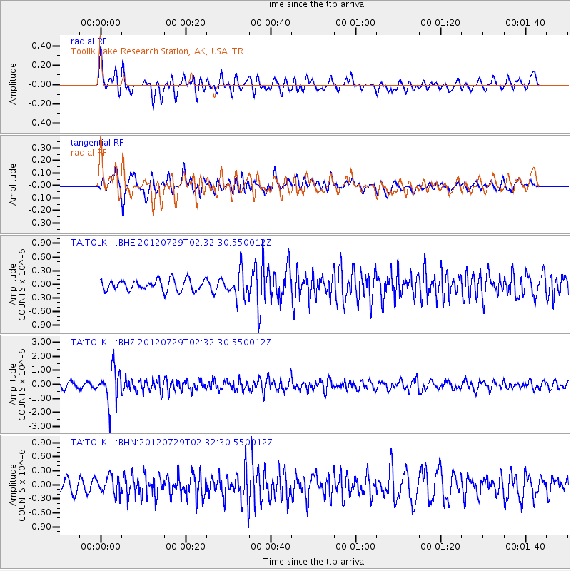
TOLK Toolik Lake Research Station, AK, USA - Earthquake Result Viewer
*The percent match for this event was below the threshold and hence no stack was calculated.
| Earthquake location: |
Myanmar |
| Earthquake latitude/longitude: |
22.9/94.3 |
| Earthquake time(UTC): |
2012/07/29 (211) 02:21:12 GMT |
| Earthquake Depth: |
75 km |
| Earthquake Magnitude: |
5.8 MB, 5.7 MW, 5.8 MW |
| Earthquake Catalog/Contributor: |
WHDF/NEIC |
|
| Network: |
TA USArray Transportable Network (new EarthScope stations) |
| Station: |
TOLK Toolik Lake Research Station, AK, USA |
| Lat/Lon: |
68.64 N/149.57 W |
| Elevation: |
760 m |
|
| Distance: |
77.8 deg |
| Az: |
19.666 deg |
| Baz: |
302.125 deg |
| Ray Param: |
$rayparam |
*The percent match for this event was below the threshold and hence was not used in the summary stack. |
|
| Radial Match: |
66.90239 % |
| Radial Bump: |
400 |
| Transverse Match: |
69.78777 % |
| Transverse Bump: |
400 |
| SOD ConfigId: |
469095 |
| Insert Time: |
2013-02-22 01:27:10.802 +0000 |
| GWidth: |
2.5 |
| Max Bumps: |
400 |
| Tol: |
0.001 |
|
Signal To Noise
| Channel | StoN | STA | LTA |
| TA:TOLK: :BHZ:20120729T02:32:30.550012Z | 8.540855 | 1.2141138E-6 | 1.4215365E-7 |
| TA:TOLK: :BHN:20120729T02:32:30.550012Z | 1.3844316 | 1.8693788E-7 | 1.3502861E-7 |
| TA:TOLK: :BHE:20120729T02:32:30.550012Z | 2.4035125 | 2.8512522E-7 | 1.1862856E-7 |
| Arrivals |
| Ps | |
| PpPs | |
| PsPs/PpSs | |


