You are here: Home > Network List > G - GEOSCOPE Stations List
> Station TAM Tamanrasset, Algeria > Earthquake Result Viewer
TAM Tamanrasset, Algeria - Earthquake Result Viewer
| Earthquake location: |
Santiago Del Estero Prov., Arg. |
| Earthquake latitude/longitude: |
-26.8/-63.4 |
| Earthquake time(UTC): |
1991/06/23 (174) 21:22:30 GMT |
| Earthquake Depth: |
581 km |
| Earthquake Magnitude: |
6.4 MB, 6.2 UNKNOWN |
| Earthquake Catalog/Contributor: |
WHDF/NEIC |
|
| Network: |
G GEOSCOPE |
| Station: |
TAM Tamanrasset, Algeria |
| Lat/Lon: |
22.79 N/5.53 E |
| Elevation: |
1377 m |
|
| Distance: |
82.9 deg |
| Az: |
60.205 deg |
| Baz: |
237.176 deg |
| Ray Param: |
0.044835806 |
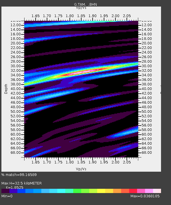
| Estimated Moho Depth: |
32.5 km |
| Estimated Crust Vp/Vs: |
1.85 |
| Assumed Crust Vp: |
6.61 km/s |
| Estimated Crust Vs: |
3.568 km/s |
| Estimated Crust Poisson's Ratio: |
0.29 |
|
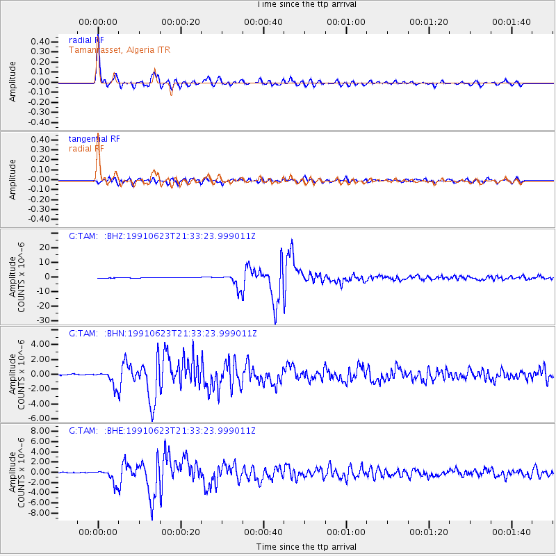
| Radial Match: |
99.16589 % |
| Radial Bump: |
398 |
| Transverse Match: |
95.77463 % |
| Transverse Bump: |
400 |
| SOD ConfigId: |
16938 |
| Insert Time: |
2010-02-27 00:25:38.476 +0000 |
| GWidth: |
2.5 |
| Max Bumps: |
400 |
| Tol: |
0.001 |
|
Signal To Noise
| Channel | StoN | STA | LTA |
| G:TAM: :BHN:19910623T21:33:23.999011Z | 15.763819 | 1.0867764E-6 | 6.894119E-8 |
| G:TAM: :BHE:19910623T21:33:23.999011Z | 18.900013 | 1.4790196E-6 | 7.825495E-8 |
| G:TAM: :BHZ:19910623T21:33:23.999011Z | 32.701706 | 5.1629513E-6 | 1.578802E-7 |
| Arrivals |
| Ps | 4.3 SECOND |
| PpPs | 14 SECOND |
| PsPs/PpSs | 18 SECOND |


