You are here: Home > Network List > G - GEOSCOPE Stations List
> Station TAM Tamanrasset, Algeria > Earthquake Result Viewer
TAM Tamanrasset, Algeria - Earthquake Result Viewer
| Earthquake location: |
Central Peru |
| Earthquake latitude/longitude: |
-13.3/-72.4 |
| Earthquake time(UTC): |
1991/07/06 (187) 12:19:45 GMT |
| Earthquake Depth: |
85 km |
| Earthquake Magnitude: |
6.3 MB |
| Earthquake Catalog/Contributor: |
WHDF/NEIC |
|
| Network: |
G GEOSCOPE |
| Station: |
TAM Tamanrasset, Algeria |
| Lat/Lon: |
22.79 N/5.53 E |
| Elevation: |
1377 m |
|
| Distance: |
84.3 deg |
| Az: |
65.097 deg |
| Baz: |
253.107 deg |
| Ray Param: |
0.045414113 |
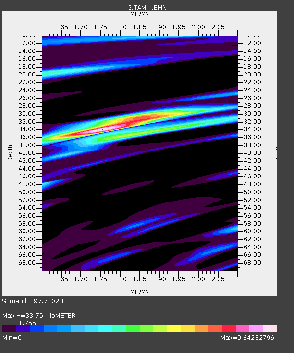
| Estimated Moho Depth: |
33.75 km |
| Estimated Crust Vp/Vs: |
1.75 |
| Assumed Crust Vp: |
6.61 km/s |
| Estimated Crust Vs: |
3.766 km/s |
| Estimated Crust Poisson's Ratio: |
0.26 |
|
| Radial Match: |
97.71028 % |
| Radial Bump: |
317 |
| Transverse Match: |
90.087074 % |
| Transverse Bump: |
400 |
| SOD ConfigId: |
16938 |
| Insert Time: |
2010-02-27 00:25:39.657 +0000 |
| GWidth: |
2.5 |
| Max Bumps: |
400 |
| Tol: |
0.001 |
|
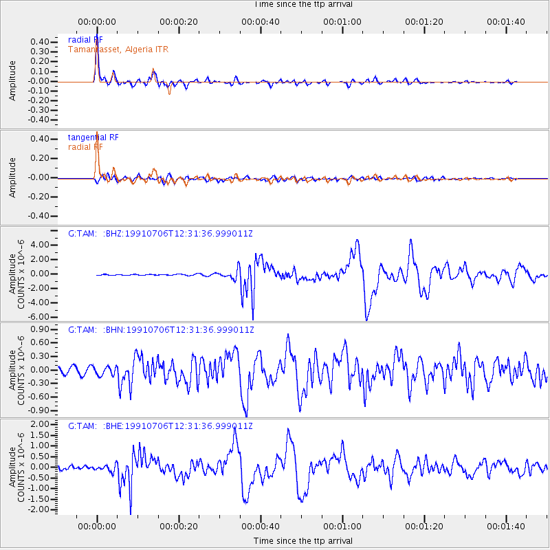
Signal To Noise
| Channel | StoN | STA | LTA |
| G:TAM: :BHN:19910706T12:31:36.999011Z | 1.8190306 | 9.331798E-8 | 5.1300937E-8 |
| G:TAM: :BHE:19910706T12:31:36.999011Z | 2.2525027 | 1.5327296E-7 | 6.804563E-8 |
| G:TAM: :BHZ:19910706T12:31:36.999011Z | 8.620719 | 6.347739E-7 | 7.363353E-8 |
| Arrivals |
| Ps | 4.0 SECOND |
| PpPs | 14 SECOND |
| PsPs/PpSs | 18 SECOND |


