You are here: Home > Network List > G - GEOSCOPE Stations List
> Station TAM Tamanrasset, Algeria > Earthquake Result Viewer
TAM Tamanrasset, Algeria - Earthquake Result Viewer
| Earthquake location: |
Near West Coast Of Colombia |
| Earthquake latitude/longitude: |
4.6/-77.5 |
| Earthquake time(UTC): |
1991/11/19 (323) 22:28:50 GMT |
| Earthquake Depth: |
21 km |
| Earthquake Magnitude: |
6.5 MB, 7.0 MS, 6.4 UNKNOWN |
| Earthquake Catalog/Contributor: |
WHDF/NEIC |
|
| Network: |
G GEOSCOPE |
| Station: |
TAM Tamanrasset, Algeria |
| Lat/Lon: |
22.79 N/5.53 E |
| Elevation: |
1377 m |
|
| Distance: |
81.8 deg |
| Az: |
67.731 deg |
| Baz: |
271.512 deg |
| Ray Param: |
0.047299605 |
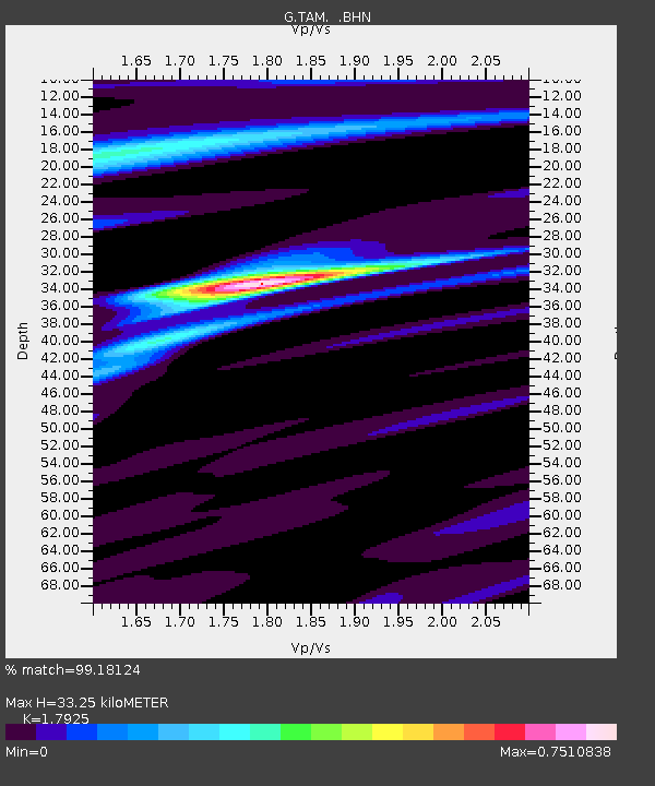
| Estimated Moho Depth: |
33.25 km |
| Estimated Crust Vp/Vs: |
1.79 |
| Assumed Crust Vp: |
6.61 km/s |
| Estimated Crust Vs: |
3.688 km/s |
| Estimated Crust Poisson's Ratio: |
0.27 |
|
| Radial Match: |
99.18124 % |
| Radial Bump: |
246 |
| Transverse Match: |
94.578995 % |
| Transverse Bump: |
400 |
| SOD ConfigId: |
16938 |
| Insert Time: |
2010-02-27 00:25:46.148 +0000 |
| GWidth: |
2.5 |
| Max Bumps: |
400 |
| Tol: |
0.001 |
|
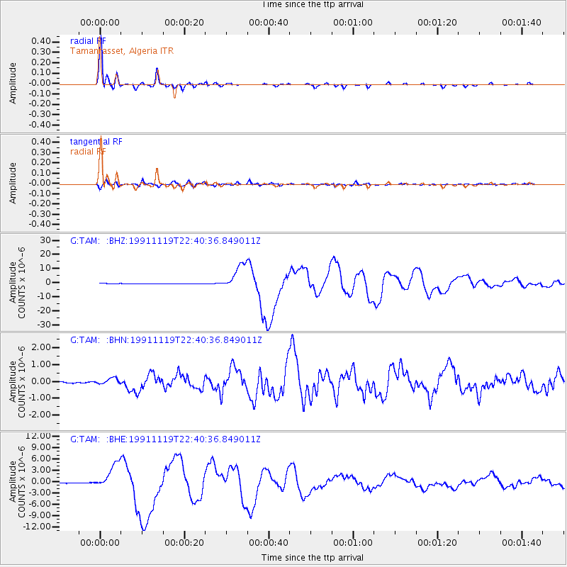
Signal To Noise
| Channel | StoN | STA | LTA |
| G:TAM: :BHN:19911119T22:40:36.849011Z | 4.0537763 | 1.9376888E-7 | 4.77996E-8 |
| G:TAM: :BHE:19911119T22:40:36.849011Z | 64.73605 | 3.5773508E-6 | 5.526056E-8 |
| G:TAM: :BHZ:19911119T22:40:36.849011Z | 80.62206 | 9.445175E-6 | 1.17153725E-7 |
| Arrivals |
| Ps | 4.1 SECOND |
| PpPs | 14 SECOND |
| PsPs/PpSs | 18 SECOND |


