You are here: Home > Network List > G - GEOSCOPE Stations List
> Station TAM Tamanrasset, Algeria > Earthquake Result Viewer
TAM Tamanrasset, Algeria - Earthquake Result Viewer
| Earthquake location: |
Northern Peru |
| Earthquake latitude/longitude: |
-3.9/-76.6 |
| Earthquake time(UTC): |
1992/07/13 (195) 18:11:34 GMT |
| Earthquake Depth: |
100 km |
| Earthquake Magnitude: |
6.2 MB |
| Earthquake Catalog/Contributor: |
WHDF/NEIC |
|
| Network: |
G GEOSCOPE |
| Station: |
TAM Tamanrasset, Algeria |
| Lat/Lon: |
22.79 N/5.53 E |
| Elevation: |
1377 m |
|
| Distance: |
84.3 deg |
| Az: |
66.747 deg |
| Baz: |
263.352 deg |
| Ray Param: |
0.045373548 |
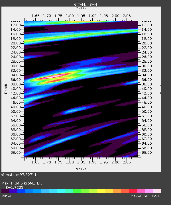
| Estimated Moho Depth: |
34.5 km |
| Estimated Crust Vp/Vs: |
1.72 |
| Assumed Crust Vp: |
6.61 km/s |
| Estimated Crust Vs: |
3.837 km/s |
| Estimated Crust Poisson's Ratio: |
0.25 |
|
| Radial Match: |
97.82711 % |
| Radial Bump: |
354 |
| Transverse Match: |
92.813156 % |
| Transverse Bump: |
400 |
| SOD ConfigId: |
16938 |
| Insert Time: |
2010-02-27 00:26:10.994 +0000 |
| GWidth: |
2.5 |
| Max Bumps: |
400 |
| Tol: |
0.001 |
|
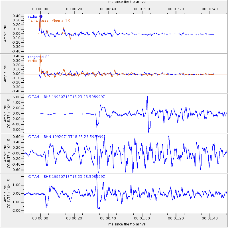
Signal To Noise
| Channel | StoN | STA | LTA |
| G:TAM: :BHN:19920713T18:23:23.598999Z | 2.8560941 | 1.8776068E-7 | 6.5740366E-8 |
| G:TAM: :BHE:19920713T18:23:23.598999Z | 12.415494 | 6.708403E-7 | 5.4032505E-8 |
| G:TAM: :BHZ:19920713T18:23:23.598999Z | 20.933784 | 2.0745215E-6 | 9.909921E-8 |
| Arrivals |
| Ps | 3.9 SECOND |
| PpPs | 14 SECOND |
| PsPs/PpSs | 18 SECOND |


