You are here: Home > Network List > UW - Pacific Northwest Regional Seismic Network Stations List
> Station MRBL Marblemount, WA, USA > Earthquake Result Viewer
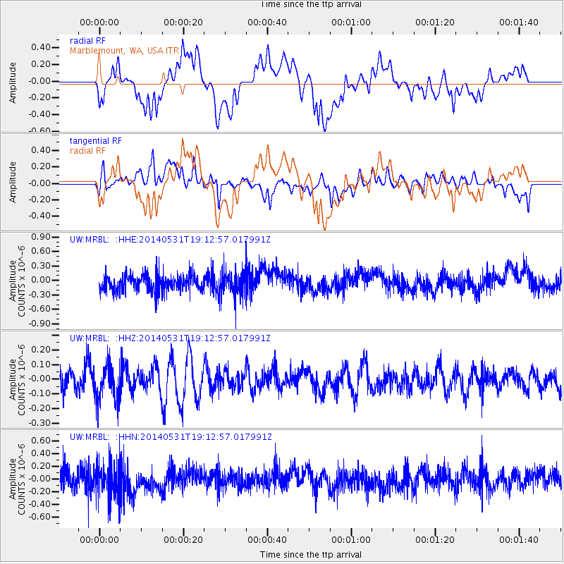
MRBL Marblemount, WA, USA - Earthquake Result Viewer
*The percent match for this event was below the threshold and hence no stack was calculated.
| Earthquake location: |
Mindanao, Philippines |
| Earthquake latitude/longitude: |
9.4/126.6 |
| Earthquake time(UTC): |
2014/05/31 (151) 19:00:00 GMT |
| Earthquake Depth: |
45 km |
| Earthquake Magnitude: |
5.2 MW |
| Earthquake Catalog/Contributor: |
ISC/ISC |
|
| Network: |
UW Pacific Northwest Regional Seismic Network |
| Station: |
MRBL Marblemount, WA, USA |
| Lat/Lon: |
48.52 N/121.48 W |
| Elevation: |
75 m |
|
| Distance: |
97.2 deg |
| Az: |
38.427 deg |
| Baz: |
292.709 deg |
| Ray Param: |
$rayparam |
*The percent match for this event was below the threshold and hence was not used in the summary stack. |
|
| Radial Match: |
43.647808 % |
| Radial Bump: |
400 |
| Transverse Match: |
54.315353 % |
| Transverse Bump: |
400 |
| SOD ConfigId: |
3390531 |
| Insert Time: |
2019-04-12 03:11:51.103 +0000 |
| GWidth: |
2.5 |
| Max Bumps: |
400 |
| Tol: |
0.001 |
|
Signal To Noise
| Channel | StoN | STA | LTA |
| UW:MRBL: :HHZ:20140531T19:12:57.017991Z | 1.4310246 | 1.2534115E-7 | 8.758839E-8 |
| UW:MRBL: :HHN:20140531T19:12:57.017991Z | 1.5036452 | 2.7522267E-7 | 1.8303699E-7 |
| UW:MRBL: :HHE:20140531T19:12:57.017991Z | 1.5574236 | 2.6305247E-7 | 1.6890232E-7 |
| Arrivals |
| Ps | |
| PpPs | |
| PsPs/PpSs | |


