You are here: Home > Network List > G - GEOSCOPE Stations List
> Station TAM Tamanrasset, Algeria > Earthquake Result Viewer
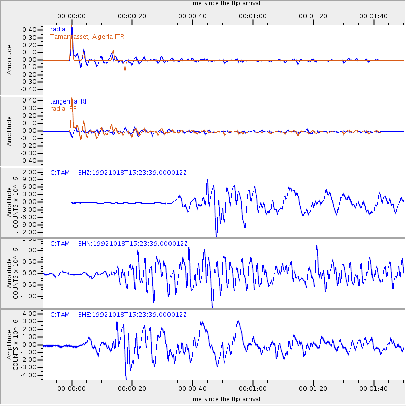
TAM Tamanrasset, Algeria - Earthquake Result Viewer

| Earthquake location: |
Northern Colombia |
| Earthquake latitude/longitude: |
7.1/-76.9 |
| Earthquake time(UTC): |
1992/10/18 (292) 15:11:59 GMT |
| Earthquake Depth: |
10 km |
| Earthquake Magnitude: |
6.6 MB, 7.3 MS, 7.4 UNKNOWN |
| Earthquake Catalog/Contributor: |
WHDF/NEIC |
|
| Network: |
G GEOSCOPE |
| Station: |
TAM Tamanrasset, Algeria |
| Lat/Lon: |
22.79 N/5.53 E |
| Elevation: |
1377 m |
|
| Distance: |
80.3 deg |
| Az: |
68.128 deg |
| Baz: |
273.677 deg |
| Ray Param: |
0.04836508 |
| Estimated Moho Depth: |
32.0 km |
| Estimated Crust Vp/Vs: |
1.82 |
| Assumed Crust Vp: |
6.61 km/s |
| Estimated Crust Vs: |
3.637 km/s |
| Estimated Crust Poisson's Ratio: |
0.28 |
|
| Radial Match: |
98.11813 % |
| Radial Bump: |
345 |
| Transverse Match: |
90.70444 % |
| Transverse Bump: |
400 |
| SOD ConfigId: |
16938 |
| Insert Time: |
2010-02-27 00:26:17.166 +0000 |
| GWidth: |
2.5 |
| Max Bumps: |
400 |
| Tol: |
0.001 |
|
Signal To Noise
| Channel | StoN | STA | LTA |
| G:TAM: :BHN:19921018T15:23:39.000012Z | 0.7044682 | 3.54628E-8 | 5.0339814E-8 |
| G:TAM: :BHE:19921018T15:23:39.000012Z | 3.3998654 | 1.8984682E-7 | 5.5839507E-8 |
| G:TAM: :BHZ:19921018T15:23:39.000012Z | 7.2332544 | 4.984861E-7 | 6.891588E-8 |
| Arrivals |
| Ps | 4.1 SECOND |
| PpPs | 13 SECOND |
| PsPs/PpSs | 17 SECOND |


