You are here: Home > Network List > TA - USArray Transportable Network (new EarthScope stations) Stations List
> Station X44A Crenshaw, MS, USA > Earthquake Result Viewer
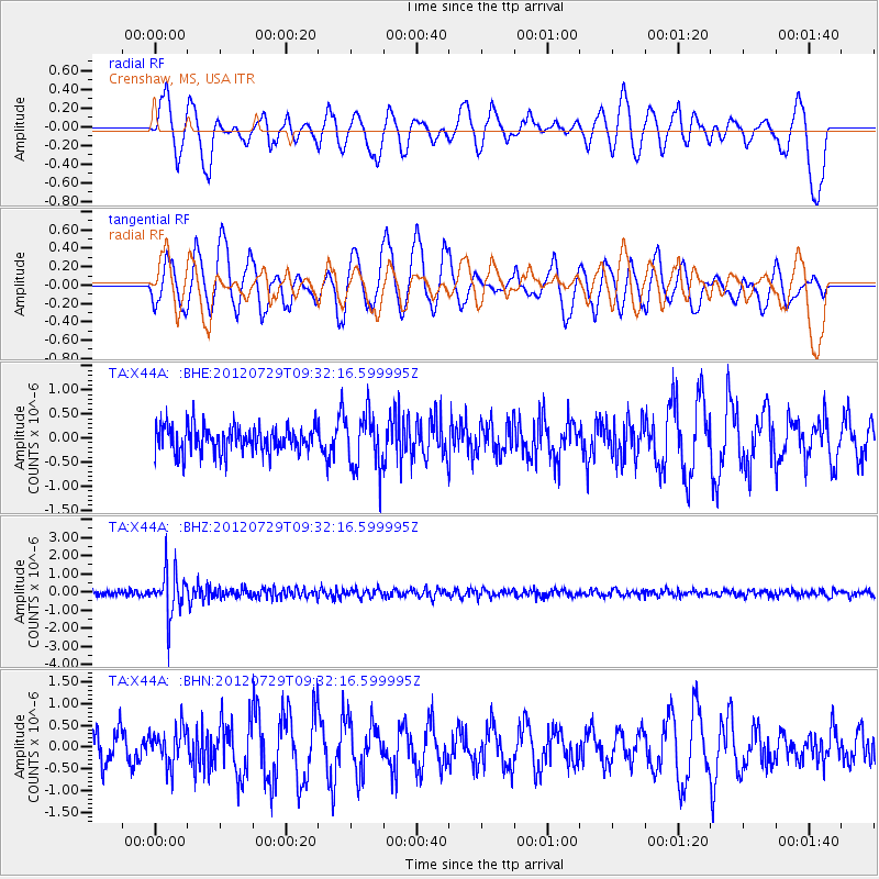
X44A Crenshaw, MS, USA - Earthquake Result Viewer
*The percent match for this event was below the threshold and hence no stack was calculated.
| Earthquake location: |
Primor'ye, Russia |
| Earthquake latitude/longitude: |
47.4/139.1 |
| Earthquake time(UTC): |
2012/07/29 (211) 09:20:54 GMT |
| Earthquake Depth: |
502 km |
| Earthquake Magnitude: |
5.6 MB, 5.6 MW, 5.7 MW |
| Earthquake Catalog/Contributor: |
WHDF/NEIC |
|
| Network: |
TA USArray Transportable Network (new EarthScope stations) |
| Station: |
X44A Crenshaw, MS, USA |
| Lat/Lon: |
34.50 N/90.15 W |
| Elevation: |
109 m |
|
| Distance: |
87.3 deg |
| Az: |
38.761 deg |
| Baz: |
328.991 deg |
| Ray Param: |
$rayparam |
*The percent match for this event was below the threshold and hence was not used in the summary stack. |
|
| Radial Match: |
38.289043 % |
| Radial Bump: |
303 |
| Transverse Match: |
68.8612 % |
| Transverse Bump: |
400 |
| SOD ConfigId: |
469095 |
| Insert Time: |
2013-02-22 02:01:11.996 +0000 |
| GWidth: |
2.5 |
| Max Bumps: |
400 |
| Tol: |
0.001 |
|
Signal To Noise
| Channel | StoN | STA | LTA |
| TA:X44A: :BHZ:20120729T09:32:16.599995Z | 7.10774 | 1.2045309E-6 | 1.694675E-7 |
| TA:X44A: :BHN:20120729T09:32:16.599995Z | 1.0295507 | 4.084353E-7 | 3.967122E-7 |
| TA:X44A: :BHE:20120729T09:32:16.599995Z | 2.0415187 | 5.594488E-7 | 2.7403559E-7 |
| Arrivals |
| Ps | |
| PpPs | |
| PsPs/PpSs | |


