You are here: Home > Network List > TA - USArray Transportable Network (new EarthScope stations) Stations List
> Station L39A Vinton, IA, USA > Earthquake Result Viewer
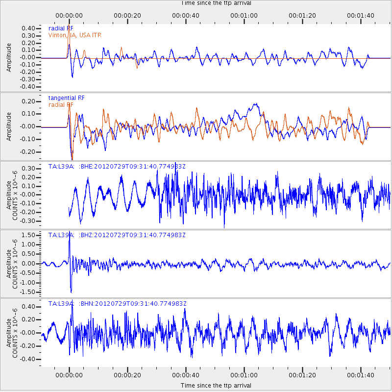
L39A Vinton, IA, USA - Earthquake Result Viewer
*The percent match for this event was below the threshold and hence no stack was calculated.
| Earthquake location: |
Primor'ye, Russia |
| Earthquake latitude/longitude: |
47.4/139.1 |
| Earthquake time(UTC): |
2012/07/29 (211) 09:20:54 GMT |
| Earthquake Depth: |
502 km |
| Earthquake Magnitude: |
5.6 MB, 5.6 MW, 5.7 MW |
| Earthquake Catalog/Contributor: |
WHDF/NEIC |
|
| Network: |
TA USArray Transportable Network (new EarthScope stations) |
| Station: |
L39A Vinton, IA, USA |
| Lat/Lon: |
42.12 N/92.00 W |
| Elevation: |
261 m |
|
| Distance: |
80.1 deg |
| Az: |
35.984 deg |
| Baz: |
327.537 deg |
| Ray Param: |
$rayparam |
*The percent match for this event was below the threshold and hence was not used in the summary stack. |
|
| Radial Match: |
44.170113 % |
| Radial Bump: |
400 |
| Transverse Match: |
58.103992 % |
| Transverse Bump: |
400 |
| SOD ConfigId: |
469095 |
| Insert Time: |
2013-02-22 02:02:57.551 +0000 |
| GWidth: |
2.5 |
| Max Bumps: |
400 |
| Tol: |
0.001 |
|
Signal To Noise
| Channel | StoN | STA | LTA |
| TA:L39A: :BHZ:20120729T09:31:40.774983Z | 5.0380454 | 5.676071E-7 | 1.12664154E-7 |
| TA:L39A: :BHN:20120729T09:31:40.774983Z | 2.0513701 | 1.792309E-7 | 8.737131E-8 |
| TA:L39A: :BHE:20120729T09:31:40.774983Z | 1.2141623 | 1.4507751E-7 | 1.1948774E-7 |
| Arrivals |
| Ps | |
| PpPs | |
| PsPs/PpSs | |


