You are here: Home > Network List > BK - Berkeley Digital Seismograph Network Stations List
> Station HUMO Hull Mountain, OR > Earthquake Result Viewer
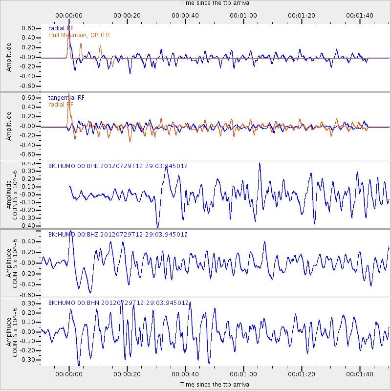
HUMO Hull Mountain, OR - Earthquake Result Viewer
*The percent match for this event was below the threshold and hence no stack was calculated.
| Earthquake location: |
Near Coast Of Chiapas, Mexico |
| Earthquake latitude/longitude: |
14.2/-92.3 |
| Earthquake time(UTC): |
2012/07/29 (211) 12:22:11 GMT |
| Earthquake Depth: |
18 km |
| Earthquake Magnitude: |
5.6 MB, 5.5 MS, 5.9 MW, 5.8 MW |
| Earthquake Catalog/Contributor: |
WHDF/NEIC |
|
| Network: |
BK Berkeley Digital Seismograph Network |
| Station: |
HUMO Hull Mountain, OR |
| Lat/Lon: |
42.61 N/122.96 W |
| Elevation: |
555 m |
|
| Distance: |
38.7 deg |
| Az: |
322.991 deg |
| Baz: |
127.742 deg |
| Ray Param: |
$rayparam |
*The percent match for this event was below the threshold and hence was not used in the summary stack. |
|
| Radial Match: |
78.78942 % |
| Radial Bump: |
400 |
| Transverse Match: |
57.307476 % |
| Transverse Bump: |
400 |
| SOD ConfigId: |
469095 |
| Insert Time: |
2013-02-22 02:28:13.791 +0000 |
| GWidth: |
2.5 |
| Max Bumps: |
400 |
| Tol: |
0.001 |
|
Signal To Noise
| Channel | StoN | STA | LTA |
| BK:HUMO:00:BHZ:20120729T12:29:03.94501Z | 5.406059 | 3.4399832E-7 | 6.3631994E-8 |
| BK:HUMO:00:BHN:20120729T12:29:03.94501Z | 4.5822883 | 1.7475631E-7 | 3.8137348E-8 |
| BK:HUMO:00:BHE:20120729T12:29:03.94501Z | 6.0167646 | 2.47811E-7 | 4.1186752E-8 |
| Arrivals |
| Ps | |
| PpPs | |
| PsPs/PpSs | |


