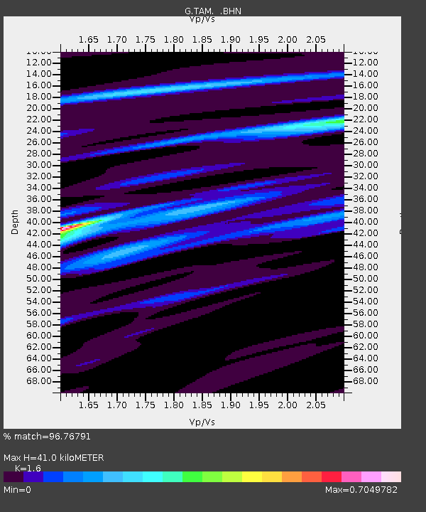
TAM Tamanrasset, Algeria - Earthquake Result Viewer
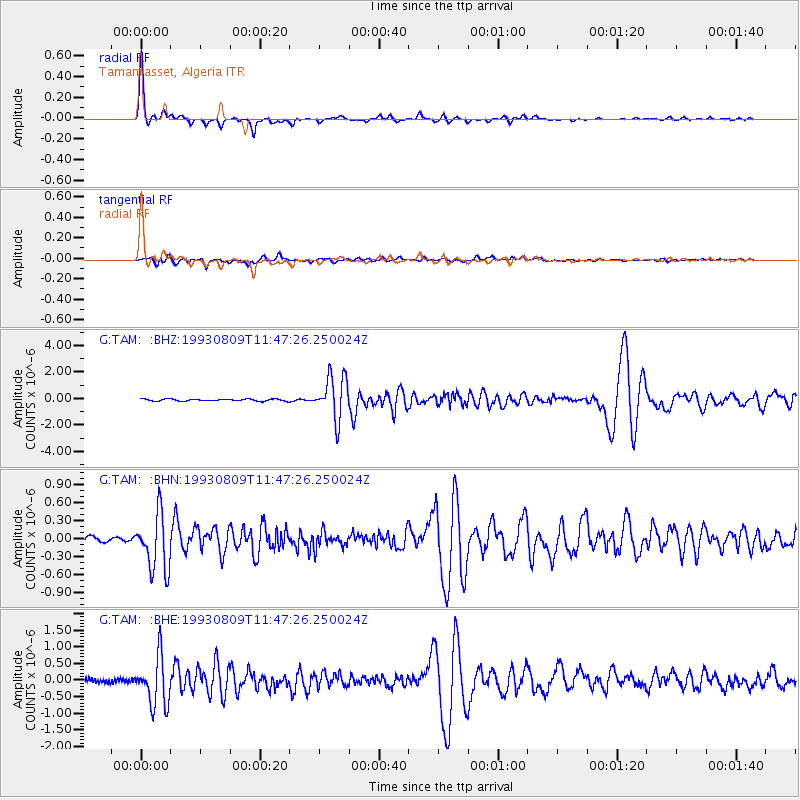
Earthquake location: Hindu Kush Region, Afghanistan
Earthquake latitude/longitude: 36.4/70.7
Earthquake time(UTC): 1993/08/09 (221) 11:38:31 GMT
Earthquake Depth: 210 km
Earthquake Magnitude: 5.8 MB, 6.3 UNKNOWN, 6.2 MW
Earthquake Catalog/Contributor: WHDF/NEIC
Network: G GEOSCOPE
Station: TAM Tamanrasset, Algeria
Lat/Lon: 22.79 N/5.53 E
Elevation: 1377 m
Distance: 57.3 deg
Az: 275.578 deg
Baz: 60.448 deg
Ray Param: 0.06287443
Estimated Moho Depth: 41.0 km
Estimated Crust Vp/Vs: 1.60
Assumed Crust Vp: 6.61 km/s
Estimated Crust Vs: 4.131 km/s
Estimated Crust Poisson's Ratio: 0.18
Radial Match: 96.76791 %
Radial Bump: 238
Transverse Match: 82.02147 %
Transverse Bump: 400
SOD ConfigId: 16938
Insert Time: 2010-02-27 00:27:07.926 +0000
GWidth: 2.5
Max Bumps: 400
Tol: 0.001

Signal To Noise

ChannelStoNSTALTA
G:TAM: :BHN:19930809T11:47:26.250024Z6.7557164.7316038E-77.0038524E-8
G:TAM: :BHE:19930809T11:47:26.250024Z12.5407927.42215E-75.9184057E-8
G:TAM: :BHZ:19930809T11:47:26.250024Z22.076351.6071267E-67.279857E-8
Arrivals
Ps3.9 SECOND
PpPs15 SECOND
PsPs/PpSs19 SECOND