You are here: Home > Network List > G - GEOSCOPE Stations List
> Station TAM Tamanrasset, Algeria > Earthquake Result Viewer
TAM Tamanrasset, Algeria - Earthquake Result Viewer
| Earthquake location: |
Hindu Kush Region, Afghanistan |
| Earthquake latitude/longitude: |
36.4/70.9 |
| Earthquake time(UTC): |
1993/08/09 (221) 12:42:49 GMT |
| Earthquake Depth: |
230 km |
| Earthquake Magnitude: |
6.3 MB, 6.9 UNKNOWN |
| Earthquake Catalog/Contributor: |
WHDF/NEIC |
|
| Network: |
G GEOSCOPE |
| Station: |
TAM Tamanrasset, Algeria |
| Lat/Lon: |
22.79 N/5.53 E |
| Elevation: |
1377 m |
|
| Distance: |
57.4 deg |
| Az: |
275.687 deg |
| Baz: |
60.503 deg |
| Ray Param: |
0.06272517 |
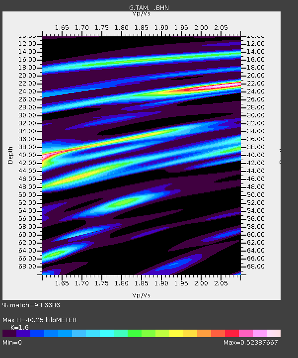
| Estimated Moho Depth: |
40.25 km |
| Estimated Crust Vp/Vs: |
1.60 |
| Assumed Crust Vp: |
6.61 km/s |
| Estimated Crust Vs: |
4.131 km/s |
| Estimated Crust Poisson's Ratio: |
0.18 |
|
| Radial Match: |
98.6686 % |
| Radial Bump: |
223 |
| Transverse Match: |
91.80995 % |
| Transverse Bump: |
400 |
| SOD ConfigId: |
16938 |
| Insert Time: |
2010-02-27 00:27:09.525 +0000 |
| GWidth: |
2.5 |
| Max Bumps: |
400 |
| Tol: |
0.001 |
|
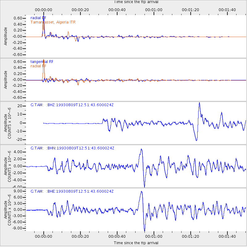
Signal To Noise
| Channel | StoN | STA | LTA |
| G:TAM: :BHN:19930809T12:51:43.600024Z | 6.725802 | 5.685912E-7 | 8.45388E-8 |
| G:TAM: :BHE:19930809T12:51:43.600024Z | 13.247271 | 1.1905227E-6 | 8.986928E-8 |
| G:TAM: :BHZ:19930809T12:51:43.600024Z | 20.26124 | 2.563669E-6 | 1.2653072E-7 |
| Arrivals |
| Ps | 3.9 SECOND |
| PpPs | 15 SECOND |
| PsPs/PpSs | 19 SECOND |


