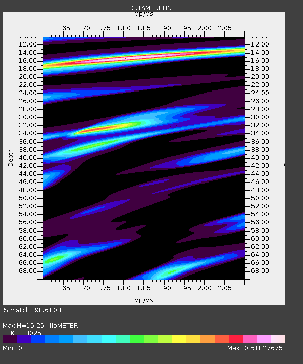
TAM Tamanrasset, Algeria - Earthquake Result Viewer
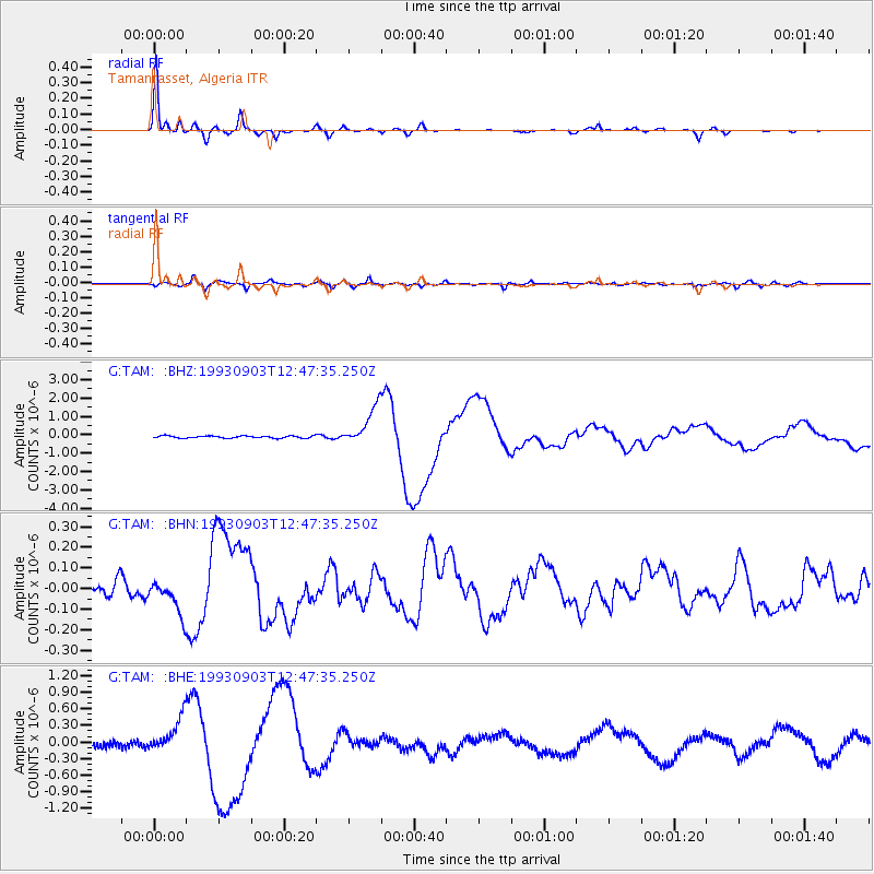
Earthquake location: Near Coast Of Chiapas, Mexico
Earthquake latitude/longitude: 14.6/-92.8
Earthquake time(UTC): 1993/09/03 (246) 12:35:01 GMT
Earthquake Depth: 33 km
Earthquake Magnitude: 5.8 MB, 6.8 MS, 6.8 UNKNOWN, 6.8 MW
Earthquake Catalog/Contributor: WHDF/NEIC
Network: G GEOSCOPE
Station: TAM Tamanrasset, Algeria
Lat/Lon: 22.79 N/5.53 E
Elevation: 1377 m
Distance: 91.9 deg
Az: 66.007 deg
Baz: 286.54 deg
Ray Param: 0.04152849
Estimated Moho Depth: 15.25 km
Estimated Crust Vp/Vs: 1.80
Assumed Crust Vp: 6.61 km/s
Estimated Crust Vs: 3.667 km/s
Estimated Crust Poisson's Ratio: 0.28
Radial Match: 98.61081 %
Radial Bump: 300
Transverse Match: 80.56382 %
Transverse Bump: 400
SOD ConfigId: 16938
Insert Time: 2010-02-27 00:27:11.240 +0000
GWidth: 2.5
Max Bumps: 400
Tol: 0.001

Signal To Noise

ChannelStoNSTALTA
G:TAM: :BHN:19930903T12:47:35.250Z2.03575068.7325E-84.2895724E-8
G:TAM: :BHE:19930903T12:47:35.250Z5.4147473.2643848E-76.028693E-8
G:TAM: :BHZ:19930903T12:47:35.250Z17.344321.0480902E-66.042844E-8
Arrivals
Ps1.9 SECOND
PpPs6.3 SECOND
PsPs/PpSs8.2 SECOND