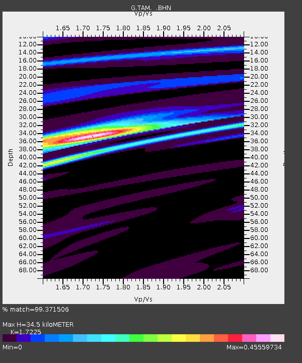
TAM Tamanrasset, Algeria - Earthquake Result Viewer

Earthquake location: Near Coast Of Chiapas, Mexico
Earthquake latitude/longitude: 14.7/-92.7
Earthquake time(UTC): 1993/09/10 (253) 19:12:54 GMT
Earthquake Depth: 34 km
Earthquake Magnitude: 6.3 MB, 7.3 MS, 7.2 UNKNOWN, 7.2 MW
Earthquake Catalog/Contributor: WHDF/NEIC
Network: G GEOSCOPE
Station: TAM Tamanrasset, Algeria
Lat/Lon: 22.79 N/5.53 E
Elevation: 1377 m
Distance: 91.7 deg
Az: 66.039 deg
Baz: 286.651 deg
Ray Param: 0.041558012
Estimated Moho Depth: 34.5 km
Estimated Crust Vp/Vs: 1.72
Assumed Crust Vp: 6.61 km/s
Estimated Crust Vs: 3.837 km/s
Estimated Crust Poisson's Ratio: 0.25
Radial Match: 99.371506 %
Radial Bump: 166
Transverse Match: 92.39066 %
Transverse Bump: 400
SOD ConfigId: 16938
Insert Time: 2010-02-27 00:27:15.900 +0000
GWidth: 2.5
Max Bumps: 400
Tol: 0.001

Signal To Noise

ChannelStoNSTALTA
G:TAM: :BHN:19930910T19:25:27.500012Z2.52324461.2704041E-75.0348035E-8
G:TAM: :BHE:19930910T19:25:27.500012Z6.4198245.442596E-78.477796E-8
G:TAM: :BHZ:19930910T19:25:27.500012Z18.9900571.8840748E-69.921375E-8
Arrivals
Ps3.9 SECOND
PpPs14 SECOND
PsPs/PpSs18 SECOND