You are here: Home > Network List > G - GEOSCOPE Stations List
> Station TAM Tamanrasset, Algeria > Earthquake Result Viewer
TAM Tamanrasset, Algeria - Earthquake Result Viewer
| Earthquake location: |
South Atlantic Ocean |
| Earthquake latitude/longitude: |
-53.6/-51.5 |
| Earthquake time(UTC): |
1993/09/27 (270) 13:37:32 GMT |
| Earthquake Depth: |
33 km |
| Earthquake Magnitude: |
6.1 MB, 6.4 MS, 6.3 UNKNOWN, 6.7 MW |
| Earthquake Catalog/Contributor: |
WHDF/NEIC |
|
| Network: |
G GEOSCOPE |
| Station: |
TAM Tamanrasset, Algeria |
| Lat/Lon: |
22.79 N/5.53 E |
| Elevation: |
1377 m |
|
| Distance: |
90.6 deg |
| Az: |
50.751 deg |
| Baz: |
209.97 deg |
| Ray Param: |
0.04165723 |
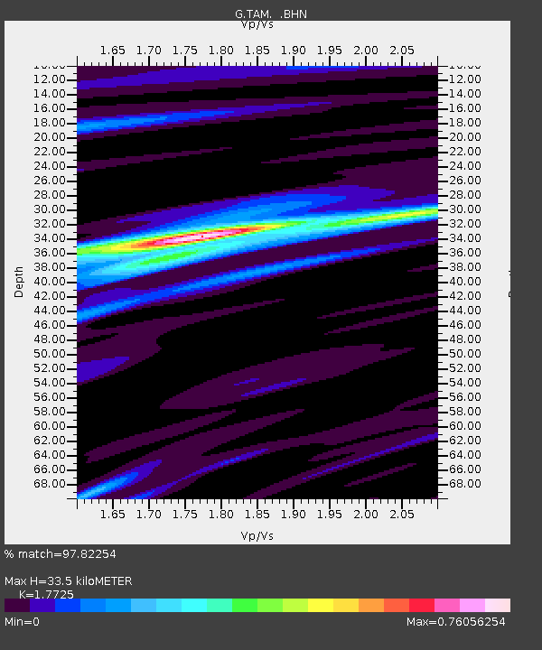
| Estimated Moho Depth: |
33.5 km |
| Estimated Crust Vp/Vs: |
1.77 |
| Assumed Crust Vp: |
6.61 km/s |
| Estimated Crust Vs: |
3.729 km/s |
| Estimated Crust Poisson's Ratio: |
0.27 |
|
| Radial Match: |
97.82254 % |
| Radial Bump: |
273 |
| Transverse Match: |
82.7507 % |
| Transverse Bump: |
400 |
| SOD ConfigId: |
16938 |
| Insert Time: |
2010-02-27 00:27:24.364 +0000 |
| GWidth: |
2.5 |
| Max Bumps: |
400 |
| Tol: |
0.001 |
|
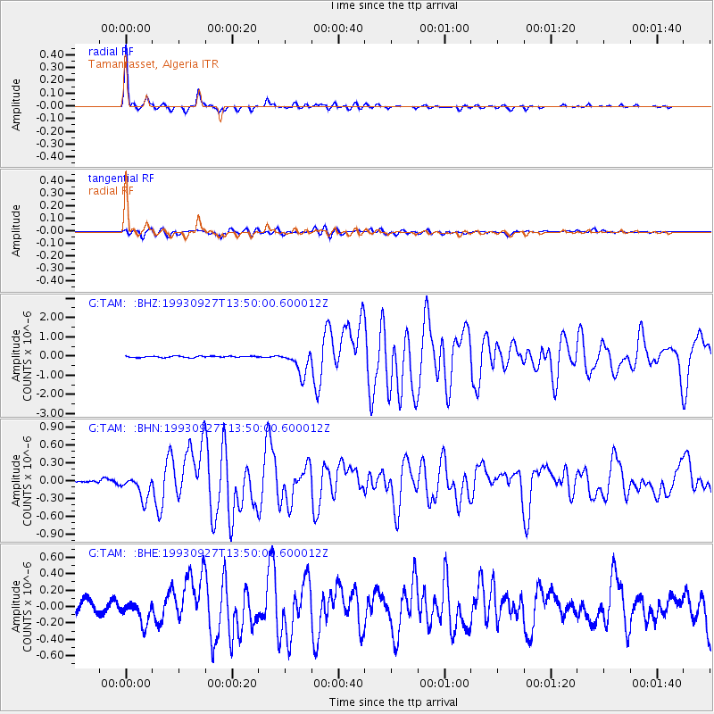
Signal To Noise
| Channel | StoN | STA | LTA |
| G:TAM: :BHN:19930927T13:50:00.600012Z | 5.4898443 | 1.9122595E-7 | 3.4832674E-8 |
| G:TAM: :BHE:19930927T13:50:00.600012Z | 1.5662448 | 1.2668261E-7 | 8.088301E-8 |
| G:TAM: :BHZ:19930927T13:50:00.600012Z | 18.308214 | 6.1906303E-7 | 3.3813404E-8 |
| Arrivals |
| Ps | 4.0 SECOND |
| PpPs | 14 SECOND |
| PsPs/PpSs | 18 SECOND |


