You are here: Home > Network List > G - GEOSCOPE Stations List
> Station TAM Tamanrasset, Algeria > Earthquake Result Viewer
TAM Tamanrasset, Algeria - Earthquake Result Viewer
| Earthquake location: |
Southern India |
| Earthquake latitude/longitude: |
18.1/76.4 |
| Earthquake time(UTC): |
1993/09/29 (272) 22:25:48 GMT |
| Earthquake Depth: |
6.0 km |
| Earthquake Magnitude: |
6.3 MB, 6.3 MS, 6.1 UNKNOWN, 6.1 MW |
| Earthquake Catalog/Contributor: |
WHDF/NEIC |
|
| Network: |
G GEOSCOPE |
| Station: |
TAM Tamanrasset, Algeria |
| Lat/Lon: |
22.79 N/5.53 E |
| Elevation: |
1377 m |
|
| Distance: |
66.0 deg |
| Az: |
287.407 deg |
| Baz: |
79.639 deg |
| Ray Param: |
0.05788035 |
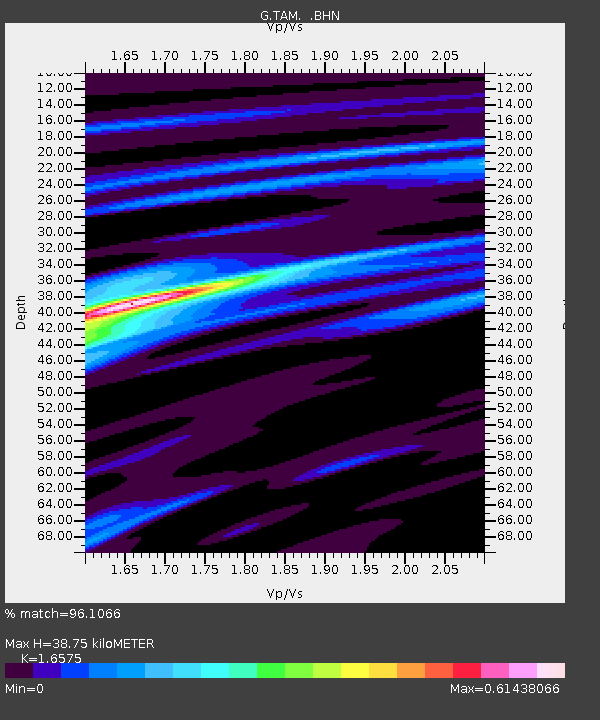
| Estimated Moho Depth: |
38.75 km |
| Estimated Crust Vp/Vs: |
1.66 |
| Assumed Crust Vp: |
6.61 km/s |
| Estimated Crust Vs: |
3.988 km/s |
| Estimated Crust Poisson's Ratio: |
0.21 |
|
| Radial Match: |
96.1066 % |
| Radial Bump: |
262 |
| Transverse Match: |
83.31386 % |
| Transverse Bump: |
400 |
| SOD ConfigId: |
16938 |
| Insert Time: |
2010-02-27 00:27:26.610 +0000 |
| GWidth: |
2.5 |
| Max Bumps: |
400 |
| Tol: |
0.001 |
|
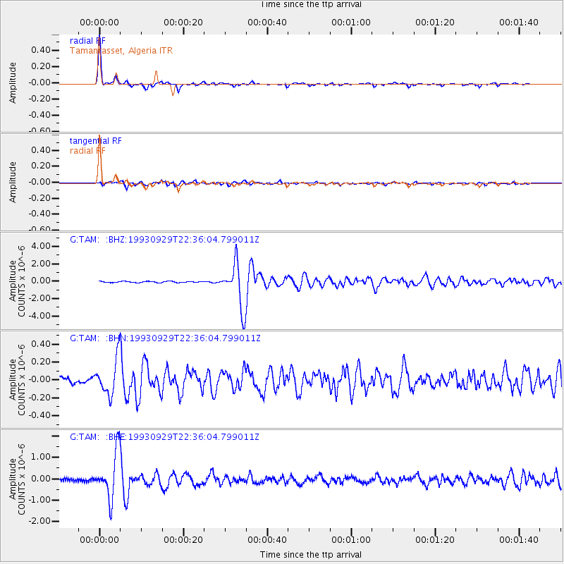
Signal To Noise
| Channel | StoN | STA | LTA |
| G:TAM: :BHN:19930929T22:36:04.799011Z | 5.304386 | 2.0589265E-7 | 3.8815546E-8 |
| G:TAM: :BHE:19930929T22:36:04.799011Z | 18.064318 | 1.1119508E-6 | 6.15551E-8 |
| G:TAM: :BHZ:19930929T22:36:04.799011Z | 38.849606 | 2.6466955E-6 | 6.81267E-8 |
| Arrivals |
| Ps | 4.0 SECOND |
| PpPs | 15 SECOND |
| PsPs/PpSs | 19 SECOND |


