You are here: Home > Network List > NE - New England Seismic Network Stations List
> Station WVL Waterville, ME, USA > Earthquake Result Viewer
WVL Waterville, ME, USA - Earthquake Result Viewer
| Earthquake location: |
Near Coast Of Chiapas, Mexico |
| Earthquake latitude/longitude: |
14.2/-92.3 |
| Earthquake time(UTC): |
2012/07/29 (211) 12:22:11 GMT |
| Earthquake Depth: |
18 km |
| Earthquake Magnitude: |
5.6 MB, 5.5 MS, 5.9 MW, 5.8 MW |
| Earthquake Catalog/Contributor: |
WHDF/NEIC |
|
| Network: |
NE New England Seismic Network |
| Station: |
WVL Waterville, ME, USA |
| Lat/Lon: |
44.56 N/69.66 W |
| Elevation: |
50 m |
|
| Distance: |
35.9 deg |
| Az: |
27.991 deg |
| Baz: |
219.554 deg |
| Ray Param: |
0.076965235 |
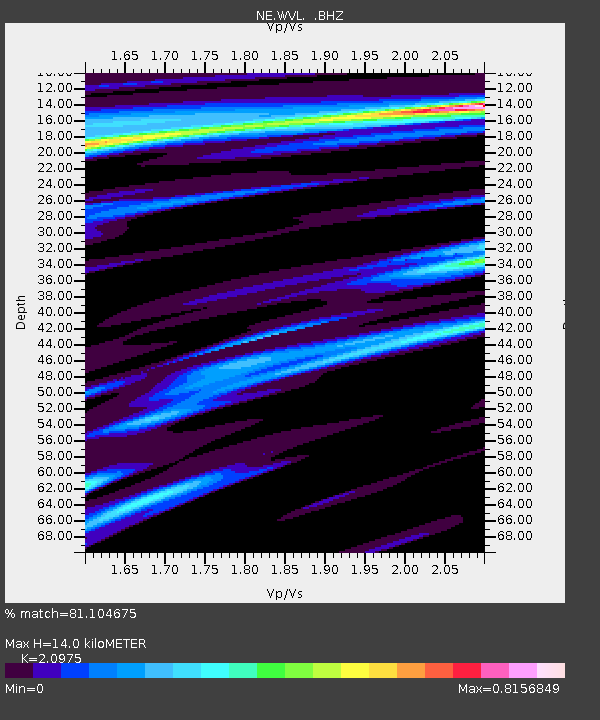
| Estimated Moho Depth: |
14.0 km |
| Estimated Crust Vp/Vs: |
2.10 |
| Assumed Crust Vp: |
6.419 km/s |
| Estimated Crust Vs: |
3.06 km/s |
| Estimated Crust Poisson's Ratio: |
0.35 |
|
| Radial Match: |
81.104675 % |
| Radial Bump: |
326 |
| Transverse Match: |
59.081585 % |
| Transverse Bump: |
389 |
| SOD ConfigId: |
469095 |
| Insert Time: |
2013-02-22 02:36:10.900 +0000 |
| GWidth: |
2.5 |
| Max Bumps: |
400 |
| Tol: |
0.001 |
|

Signal To Noise
| Channel | StoN | STA | LTA |
| NE:WVL: :BHZ:20120729T12:28:39.894991Z | 2.666486 | 3.4166527E-7 | 1.2813315E-7 |
| NE:WVL: :BHN:20120729T12:28:39.894991Z | 1.5364991 | 1.6178554E-7 | 1.05294916E-7 |
| NE:WVL: :BHE:20120729T12:28:39.894991Z | 1.1493245 | 1.3125907E-7 | 1.142054E-7 |
| Arrivals |
| Ps | 2.5 SECOND |
| PpPs | 6.3 SECOND |
| PsPs/PpSs | 8.9 SECOND |


