You are here: Home > Network List > NE - New England Seismic Network Stations List
> Station EMMW Machias, ME, USA > Earthquake Result Viewer
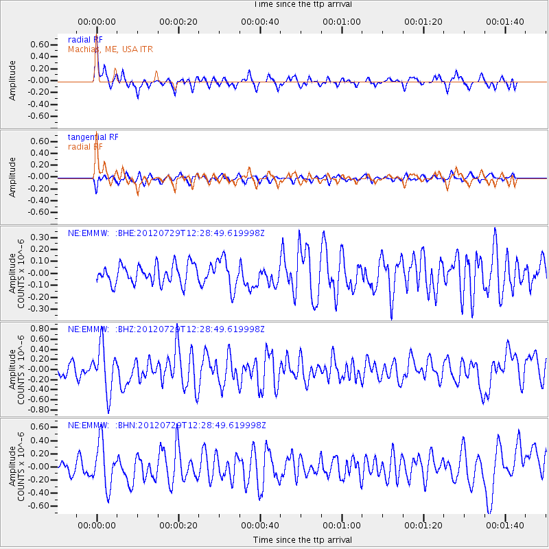
EMMW Machias, ME, USA - Earthquake Result Viewer
*The percent match for this event was below the threshold and hence no stack was calculated.
| Earthquake location: |
Near Coast Of Chiapas, Mexico |
| Earthquake latitude/longitude: |
14.2/-92.3 |
| Earthquake time(UTC): |
2012/07/29 (211) 12:22:11 GMT |
| Earthquake Depth: |
18 km |
| Earthquake Magnitude: |
5.6 MB, 5.5 MS, 5.9 MW, 5.8 MW |
| Earthquake Catalog/Contributor: |
WHDF/NEIC |
|
| Network: |
NE New England Seismic Network |
| Station: |
EMMW Machias, ME, USA |
| Lat/Lon: |
44.71 N/67.46 W |
| Elevation: |
35 m |
|
| Distance: |
37.0 deg |
| Az: |
29.831 deg |
| Baz: |
222.577 deg |
| Ray Param: |
$rayparam |
*The percent match for this event was below the threshold and hence was not used in the summary stack. |
|
| Radial Match: |
71.21921 % |
| Radial Bump: |
359 |
| Transverse Match: |
62.48885 % |
| Transverse Bump: |
400 |
| SOD ConfigId: |
469095 |
| Insert Time: |
2013-02-22 02:36:12.807 +0000 |
| GWidth: |
2.5 |
| Max Bumps: |
400 |
| Tol: |
0.001 |
|
Signal To Noise
| Channel | StoN | STA | LTA |
| NE:EMMW: :BHZ:20120729T12:28:49.619998Z | 3.59892 | 4.6546475E-7 | 1.2933457E-7 |
| NE:EMMW: :BHN:20120729T12:28:49.619998Z | 3.019081 | 3.4562612E-7 | 1.14480564E-7 |
| NE:EMMW: :BHE:20120729T12:28:49.619998Z | 1.7016926 | 1.327952E-7 | 7.8037125E-8 |
| Arrivals |
| Ps | |
| PpPs | |
| PsPs/PpSs | |


