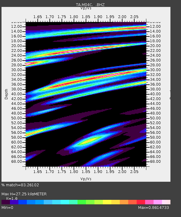
M04C Macdoel, CA, USA - Earthquake Result Viewer

Earthquake location: Near Coast Of Chiapas, Mexico
Earthquake latitude/longitude: 14.2/-92.3
Earthquake time(UTC): 2012/07/29 (211) 12:22:11 GMT
Earthquake Depth: 18 km
Earthquake Magnitude: 5.6 MB, 5.5 MS, 5.9 MW, 5.8 MW
Earthquake Catalog/Contributor: WHDF/NEIC
Network: TA USArray Transportable Network (new EarthScope stations)
Station: M04C Macdoel, CA, USA
Lat/Lon: 41.78 N/121.84 W
Elevation: 1391 m
Distance: 37.6 deg
Az: 322.768 deg
Baz: 128.315 deg
Ray Param: 0.07605214
Estimated Moho Depth: 27.25 km
Estimated Crust Vp/Vs: 1.60
Assumed Crust Vp: 6.566 km/s
Estimated Crust Vs: 4.104 km/s
Estimated Crust Poisson's Ratio: 0.18
Radial Match: 83.26102 %
Radial Bump: 340
Transverse Match: 75.31803 %
Transverse Bump: 400
SOD ConfigId: 469095
Insert Time: 2013-02-22 02:37:11.781 +0000
GWidth: 2.5
Max Bumps: 400
Tol: 0.001

Signal To Noise

ChannelStoNSTALTA
TA:M04C: :BHZ:20120729T12:28:54.149996Z17.6736561.158651E-66.5558076E-8
TA:M04C: :BHN:20120729T12:28:54.149996Z4.10110473.353046E-78.175958E-8
TA:M04C: :BHE:20120729T12:28:54.149996Z4.51334865.2200767E-71.15658615E-7
Arrivals
Ps2.7 SECOND
PpPs9.9 SECOND
PsPs/PpSs13 SECOND