You are here: Home > Network List > TA - USArray Transportable Network (new EarthScope stations) Stations List
> Station J05D Fort Rock, OR, USA > Earthquake Result Viewer
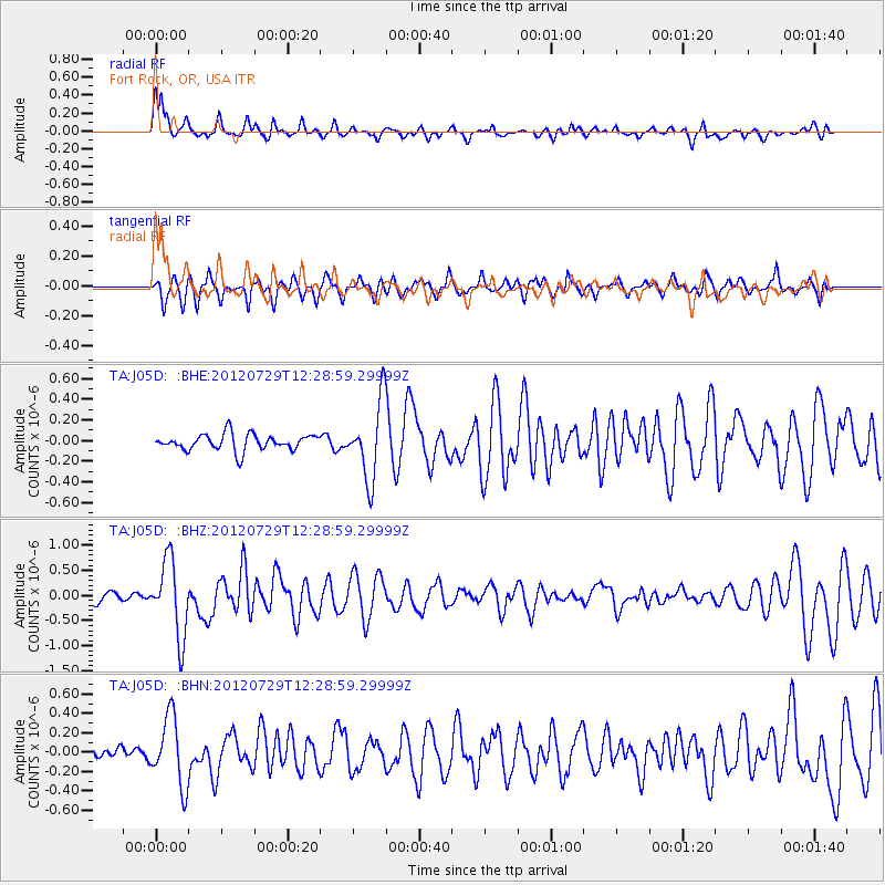
J05D Fort Rock, OR, USA - Earthquake Result Viewer
*The percent match for this event was below the threshold and hence no stack was calculated.
| Earthquake location: |
Near Coast Of Chiapas, Mexico |
| Earthquake latitude/longitude: |
14.2/-92.3 |
| Earthquake time(UTC): |
2012/07/29 (211) 12:22:11 GMT |
| Earthquake Depth: |
18 km |
| Earthquake Magnitude: |
5.6 MB, 5.5 MS, 5.9 MW, 5.8 MW |
| Earthquake Catalog/Contributor: |
WHDF/NEIC |
|
| Network: |
TA USArray Transportable Network (new EarthScope stations) |
| Station: |
J05D Fort Rock, OR, USA |
| Lat/Lon: |
43.28 N/121.23 W |
| Elevation: |
1541 m |
|
| Distance: |
38.2 deg |
| Az: |
325.12 deg |
| Baz: |
130.579 deg |
| Ray Param: |
$rayparam |
*The percent match for this event was below the threshold and hence was not used in the summary stack. |
|
| Radial Match: |
77.01087 % |
| Radial Bump: |
343 |
| Transverse Match: |
68.650475 % |
| Transverse Bump: |
385 |
| SOD ConfigId: |
469095 |
| Insert Time: |
2013-02-22 02:37:54.836 +0000 |
| GWidth: |
2.5 |
| Max Bumps: |
400 |
| Tol: |
0.001 |
|
Signal To Noise
| Channel | StoN | STA | LTA |
| TA:J05D: :BHZ:20120729T12:28:59.29999Z | 9.094732 | 7.51169E-7 | 8.259386E-8 |
| TA:J05D: :BHN:20120729T12:28:59.29999Z | 6.471448 | 3.5326232E-7 | 5.4587833E-8 |
| TA:J05D: :BHE:20120729T12:28:59.29999Z | 4.748754 | 3.7227403E-7 | 7.839404E-8 |
| Arrivals |
| Ps | |
| PpPs | |
| PsPs/PpSs | |


