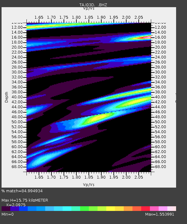
I03D Drain, OR, USA - Earthquake Result Viewer

Earthquake location: Near Coast Of Chiapas, Mexico
Earthquake latitude/longitude: 14.2/-92.3
Earthquake time(UTC): 2012/07/29 (211) 12:22:11 GMT
Earthquake Depth: 18 km
Earthquake Magnitude: 5.6 MB, 5.5 MS, 5.9 MW, 5.8 MW
Earthquake Catalog/Contributor: WHDF/NEIC
Network: TA USArray Transportable Network (new EarthScope stations)
Station: I03D Drain, OR, USA
Lat/Lon: 43.70 N/123.35 W
Elevation: 140 m
Distance: 39.6 deg
Az: 324.07 deg
Baz: 128.312 deg
Ray Param: 0.074861854
Estimated Moho Depth: 15.75 km
Estimated Crust Vp/Vs: 2.10
Assumed Crust Vp: 6.522 km/s
Estimated Crust Vs: 3.109 km/s
Estimated Crust Poisson's Ratio: 0.35
Radial Match: 84.994934 %
Radial Bump: 398
Transverse Match: 81.03434 %
Transverse Bump: 400
SOD ConfigId: 469095
Insert Time: 2013-02-22 02:38:07.803 +0000
GWidth: 2.5
Max Bumps: 400
Tol: 0.001

Signal To Noise

ChannelStoNSTALTA
TA:I03D: :BHZ:20120729T12:29:11.42499Z15.2451199.75519E-76.398894E-8
TA:I03D: :BHN:20120729T12:29:11.42499Z6.7249433.9016848E-75.801811E-8
TA:I03D: :BHE:20120729T12:29:11.42499Z6.93858244.7988993E-76.916254E-8
Arrivals
Ps2.8 SECOND
PpPs7.0 SECOND
PsPs/PpSs9.9 SECOND