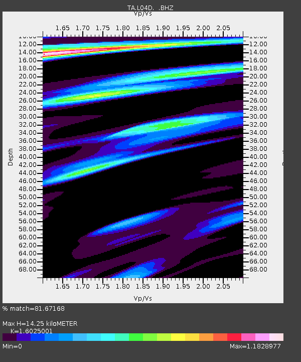
L04D Klamath Falls, OR, USA - Earthquake Result Viewer
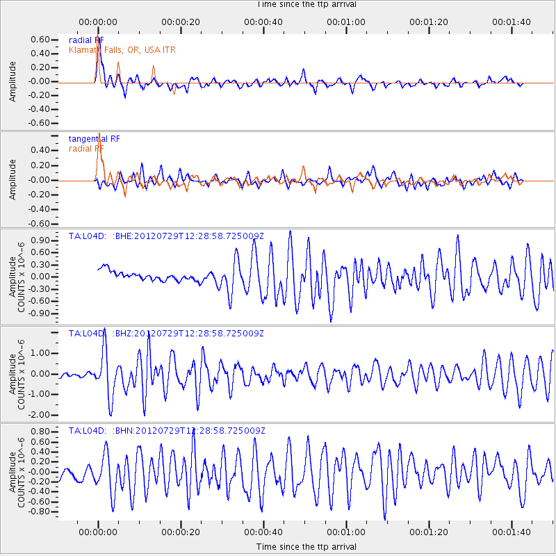
Earthquake location: Near Coast Of Chiapas, Mexico
Earthquake latitude/longitude: 14.2/-92.3
Earthquake time(UTC): 2012/07/29 (211) 12:22:11 GMT
Earthquake Depth: 18 km
Earthquake Magnitude: 5.6 MB, 5.5 MS, 5.9 MW, 5.8 MW
Earthquake Catalog/Contributor: WHDF/NEIC
Network: TA USArray Transportable Network (new EarthScope stations)
Station: L04D Klamath Falls, OR, USA
Lat/Lon: 42.22 N/122.30 W
Elevation: 1437 m
Distance: 38.1 deg
Az: 322.975 deg
Baz: 128.168 deg
Ray Param: 0.0757379
Estimated Moho Depth: 14.25 km
Estimated Crust Vp/Vs: 1.60
Assumed Crust Vp: 6.522 km/s
Estimated Crust Vs: 4.07 km/s
Estimated Crust Poisson's Ratio: 0.18
Radial Match: 81.67168 %
Radial Bump: 400
Transverse Match: 64.8847 %
Transverse Bump: 400
SOD ConfigId: 469095
Insert Time: 2013-02-22 02:38:31.843 +0000
GWidth: 2.5
Max Bumps: 400
Tol: 0.001

Signal To Noise

ChannelStoNSTALTA
TA:L04D: :BHZ:20120729T12:28:58.725009Z14.9539511.1304426E-67.559491E-8
TA:L04D: :BHN:20120729T12:28:58.725009Z2.17543964.1930204E-71.9274358E-7
TA:L04D: :BHE:20120729T12:28:58.725009Z3.66298844.0838157E-71.1148863E-7
Arrivals
Ps1.4 SECOND
PpPs5.2 SECOND
PsPs/PpSs6.7 SECOND