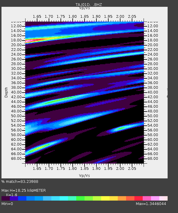
J01D Myrtle Point, OR, USA - Earthquake Result Viewer
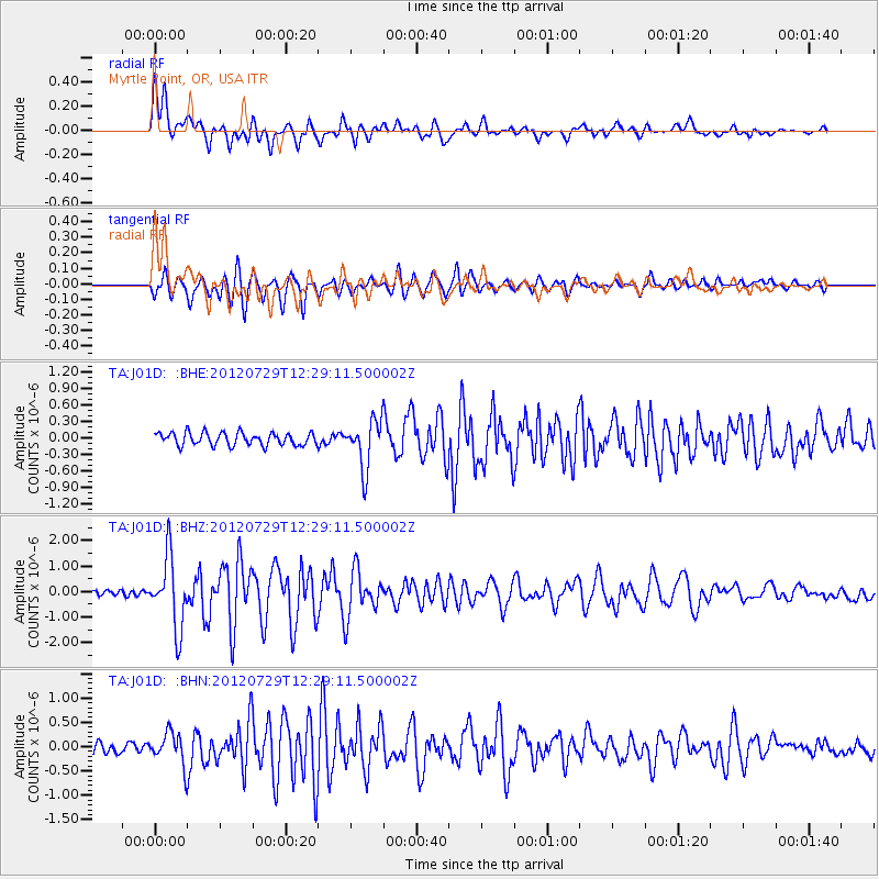
Earthquake location: Near Coast Of Chiapas, Mexico
Earthquake latitude/longitude: 14.2/-92.3
Earthquake time(UTC): 2012/07/29 (211) 12:22:11 GMT
Earthquake Depth: 18 km
Earthquake Magnitude: 5.6 MB, 5.5 MS, 5.9 MW, 5.8 MW
Earthquake Catalog/Contributor: WHDF/NEIC
Network: TA USArray Transportable Network (new EarthScope stations)
Station: J01D Myrtle Point, OR, USA
Lat/Lon: 43.16 N/123.93 W
Elevation: 131 m
Distance: 39.6 deg
Az: 322.998 deg
Baz: 127.087 deg
Ray Param: 0.07485702
Estimated Moho Depth: 18.25 km
Estimated Crust Vp/Vs: 1.60
Assumed Crust Vp: 6.522 km/s
Estimated Crust Vs: 4.076 km/s
Estimated Crust Poisson's Ratio: 0.18
Radial Match: 83.23988 %
Radial Bump: 400
Transverse Match: 88.7453 %
Transverse Bump: 400
SOD ConfigId: 469095
Insert Time: 2013-02-22 02:38:44.911 +0000
GWidth: 2.5
Max Bumps: 400
Tol: 0.001

Signal To Noise

ChannelStoNSTALTA
TA:J01D: :BHZ:20120729T12:29:11.500002Z10.9368281.3795127E-61.2613464E-7
TA:J01D: :BHN:20120729T12:29:11.500002Z2.50520873.2763697E-71.3078231E-7
TA:J01D: :BHE:20120729T12:29:11.500002Z3.78858694.3582097E-71.15035235E-7
Arrivals
Ps1.8 SECOND
PpPs6.7 SECOND
PsPs/PpSs8.5 SECOND